

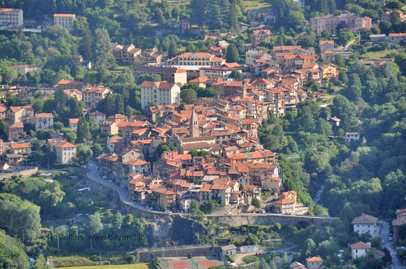
Saint Martin-Vésubie
• Alpes-Maritimes (06450) • Population: 1,041 • Altitude: 960 m
Gallery of 15 photos for Saint Martin-Vésubie

This once-fortified medieval mountain village, guarding the Col de Fenestre, sits in a magnificant location in the crook of the Parc National du Mercantour. To the north, the French-Italian border is marked by a ring of high mountains: Cime du Mercantour (2772 m), Cime Guilié (2999 m), Cime de l'Agnel (2927 m) and Cime de Gélas (3143 m). To the east the many mountains include Mont Neiller (2786 m) and the Vallon de la Madone de Fenestre. • Market day Daily.
The Boréon ( lake, waterfall, forests, rushing mountain rivers) is a beautiful region to the north, just one of many sitting amidst forests, alpine lakes, and around 30 mountain peaks (cimes) from 2500 to 3000 m high.
St. Martin-Vésubie is an excellent starting point for hiking and mountaineering. There is a Gendarmarie Mountain Rescue center in the village, and you can get the latest information on local conditions. In the small village shops you can get your supplies, including fresh fruits and vegatables; a great, locally-baked country bread has a hard (delicious) crust and is perfect for back-packing. There are also shops with hiking, camping and climbing gear, so you don't have to come here prepared. When your shopping is done, there are outdoor terrace cafes where you can wake up over a "grand crème", have some breakfast, and go over your maps, while surrounded by the high mountain peaks.
A small mountain stream actually runs down the center of the main walking street of the village. Called a gargouille, you'll have to step across it constantly as you check out the shops of the village. St. Martin and Briançon are the only villages with a gargouille.
History of Saint Martin-Vésubie
Name
First record, 12th century, dedicated to the patron-saint of St-Martin-de-Lantosque.
Medieval: originally a priory founded by the Benedictine Abbey of St-Dalmas-de-Pedona at Piémont. The Templiers who managed the sanctuary of Fenestre were arrested in 1307, an "evil" act that gave rise to several legends over the years.
Dates
Market day: Daily.
May - Annual Spring Fair
June - Fete de la St Jean
Sep - Animals en Fete and Agriculturial Fair, with Metiers d'Antan (ancient trades)
Nov - Foire Annuelle d'Hiver - Annual Winter Festival, Market
Hiking
• GPS: 44.069887, 7.25649
Maps
IGN (1/25,000) #3741 OT "Vallée de la Vésubie"
Didier Richard (1/50,000) #9 "Mercantour"
- Refuge de la Madone
- (C.A.F.) - tel: (33) 493 03 20 73; 93 02 83 19
- Club Alpin de Nice
- tel: (33) 493 62 59 99
- Maison du Parc du Mercantour
- Located just a few steps down from the Office de Tourisme. A friendly information service, and a library of maps and books about nature and the Parc for on-site reading, as well as maps for sale.
Several outstanding hiking and climbing areas are accessible from St. Martin-Vésubie.
•
Boréon. Go north about 5 km up to the Boréon, park, and hike in to the Mercantour National Park. If you don't have the time or inclination for hiking, the Boréon has picnic tables dispersed through a large area of pine trees, a 40-m high waterfall dropping into a narrow gorge, a crystal clear lake full of fish, and a café-resturant.
•
GR52A St Martin--Sospel.
The GR52A goes southeast past Belvédère and La-Bollène-Vésube, then east over the Col de Turini (1607 m) (about 40 km). From Col de Turini, the GR52A goes over Cime de Calmette (1786 m) to Moulinet and then south to Sospel (another 40 km). [total 80 km]
•
GR52A Sospel--Col de Tende.
From Sospel, the GR52A goes north over the Col de Brouis (879 m) to Breil-sur-Roya (30 km). From Breil, the trail goes north on the west side of the Roya to Saorge (20 km). From Saorge, the GR52A loops through the mountains to the east, and north past La Brigue and on to Tende (about 35 km). Tende to the Col de Tende (1871 m) is an additional 20 km. [total 105 km]
•
St Martin--St Dalmas-de-Tende.
From St Martin, the GR52A goes southeast to Belvédère (20 km). A non-GR trail goes east-northeast from Belvédère to the Col de Raus (1999 m; 20 km). The GR52 goes northeast from Col de Raus to the Refuge des Merveilles (2111 m; 12 km). From the Refuge des Merveilles, a trail goes down the Vallon de la Minière to the Lac des Mesches (14 km) and on to St Dalmas-de-Tende (a final 13 km). The Lac des Mesches is on the little St Dalmas--Casterino road. [total 80 km]
Sports
- Fishing
- Guide, Daniel Blanc - tel: (33) 493 03 28 90; 93 03 24 09
- Le Chalet des Pêcheurs - tel: (33) 493 03 24 09; from may
- Hang Gliding; Paragliding
- Hiking (magnificant; endless number of trails)
- Bureau des Guides de la Haute Vésubie
- tel: (33) 493 03 26 60; 93 03 51 60; 93 03 44 30
- Bureau des Guides du Mercantour - tel: (33) 493 03 31 32
- Mountain Guide Michel Bousquet - tel: (33) 493 56 13 56
- Bureau des Guides du Mercantour - tel: (33) 493 03 31 32
- Horseback Riding
- Denis Longfellow - tel: (33) 493 03 03 00
- Rock Climbing (mountaineering); climbing school
- Paragliding
- Ecole Professionnelle de Parapente - tel: (33) 493 02 83 88
- Skiing Cross-country - dec-apr (30 km of marked trails)
- Le Boréon - tel: (33) 493 0333 7;7; 93 03 21 28
- Bureau des Guides de la Haute Vésubie - tel: (33) 493 03 26 60
- Skiing Downhill
- Ski Alpin, La Colmiane - tel: (33) 493 02 88 59; 93 02 84 59
- Swimming Pools (Piscines)
- Piscine Municipale
- allée Verdun
- Tel: (33) 493 03 22 76
- The municipal pool is located at the town center, very handy, and was recently renovated (2004).
- Tel: (33) 493 03 22 76
Transportation Saint Martin-Vésubie
Nice - St Martin-Vésubie Bus
- Bus #730. Nice to St-Martin buses: Two Mon-Sat (morning, evening); one bus Sunday mornings. St-Martin to Nice buses: three Mon-Sat (early morning, morning, mid-day); one bus Sunday evening. Trip time 1h40. Route: Nice Gare routière, Airport Terminal 1, Colomars Gare, Plan du Var, St Jean-la-Rivière, Lantosque, Roquebillière, Berthemont, St Martin-Vésubie.