


Rimplas
• Alpes-Maritimes (06420) • Population: 84 • Altitude: 1000 m
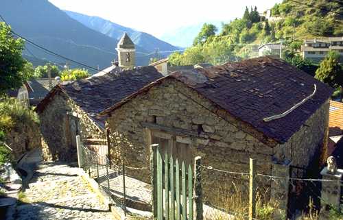
Gallery of 3 photos for Rimplas

 See map
The village is perched like an eagle's nest on the saddle of a rocky mountain spur, overlooking the Bramafan valley to the east and Tinée valley to the west and the south. From Rimplas you can see some of the other lovely villages: Marie perched on a hill down below in the valley to the south; Clans perched even further south down the Tinée; La Bolline up the Valdeblore valley to the east; Roure perched higher up on the mountainside to the northwest. Rimplas is on the "Route du Sel".
The buildings are mostly bare stone, and the narrow village streets are paved with large rectangular stones. The older houses in the village are roofed with a dark red stone (schiste rouge), a type of shist or shale from the region. On the drive back down from the village, you can see large deposits of the schiste rouge low in the Tinée valley. This stone is called "Lauze" locally.
Rimplas has a tradition of baking local bread in an ancient communal oven several hundred years old. In June they have a bread-baking festival, with delicious fresh mountain bread and several other local specialties, folk dancing, concerts, story telling and other
Getting There
Rimplas is in the Vallée de Tinée, 60 km north of Nice and about 20 km west of St. Martin-Vésubie. About 20 km up the Tinée valley, turn right towards Valdeblore. The road zig-zags up around the side of the mountain, with a few "lacets", but it's a real two-lane road with even a white line down the middle, and beautiful forested mountains and valleys all around. Seven km along this road, the little D66 road branches off for a 2-km trip up to Rimplas.
Lonely Fortifications
Concrete fortifications ring the hilltop of the high peak and the southern end of the spur overlooking Rimplas and the valleys far below. The fort was built from 1929-35, but never finished, and never really used.
Playground
As tight as space is on this rocky mountain spur, a cozy little area with shade trees was found for a playground. There's a slide, merry-go-round, teeter-totter and the frame for swings.
Commerce and Lodging
This little village has an Epicerie and the Bar-Tabac "Au Pous' Café" open year-round. There's also a nice 2-star hotel and restaurant, but it was closed in September; try the Office du Tourisme for information. The village has a Gîte Rural (reservations - tel: (33) 493 44 39 39).
History of Rimplas
Name
First record, 11th century In rege placito; 12th century: Raiplas. The name may mean the village was the county seat of the Comté de la Tinée, derived from "ragin" (Germanic for counsellor) and "placitus" (Latin for judicial assembly).
Celto-Ligurian: The Ligures were here.
Medieval: The village was destroyed around 1000 AD. It was ruled by the Lords of Thorame-Glandevès in the 12th century, the Faucon in the 14th and the Grimaldi until the Revolution. In the 18th century, the village sided with the Austrians and fought the French army -- unsuccessfully; the village was burned down by the French. It was rebuilt, and expanded to its peak glory around the turn of the 19th-20th century.
Dates
July - Fête Communale
Aug - Fête Patronale
Hiking
• GPS: 44.063217, 7.130899
Maps
IGN (1/25,000) #3641 OT "Moyenne Var"
The GR5 passes through Rimplas,
with St. Dalmas and Saint Martin-Vésubie to the east
and St-Sauveur-sur-Tinée to the west. The trail St-Sauveur (497 m) is mostly downhill.
Trails go north from Rimplas, climbing past the Cime de Ballour (1905 m)
and Collet de la Sagne (2114 m) to the Vacherie de Rimplas (2081 m).
Transportation Rimplas
Bus Line 750 Nice - Isola 2000
- 90 km (about 2h30)
- Cost (one-way): Some buses are standard, 1 euro;
some are 100% Neige, 4 € reserved online (www.lignesdazur.com); 5 € sans reservation, space permitting. - Departs Nice Vauban (then Gare SNCF, Airport term-1, term-2):
- 7h20, daily, 100% Neige
9h45, daily
11h00, weekends Feb-Mar, 100% Neige
13h00, sat, 100% Neige
16h30, daily except Fri
17h30, Fri - Return departs Isola 2000 Les Hameaux (then : Isola 2000 Station, Village
- 7h50, daily
9h20, weekends Feb-Mar, 100% Neige
12h50, sat, 100% Neige
14h50, daily
16h50, daily, 100% Neige
The Nice - Isola 2000 standard bus stops are: Nice Vauban, Gare SNCF, Magnan/Promenade, Carras/Promenade, Airport Terminal 2, Airport Terminal 1, Robini, Colomars Gare, St Martin-du-Var, Pont Charles Albert (RN 202), Plan-du-Var, Le Chaudan, La Courbaise, La Tour-sur-Tinée (gare), Roussillon, Pont-de-Clans, Bancairon, Marie (gare), La Bolinette, Rimplas (gare embranchement), St Sauveur (village), Pont de Paule, Isola Village, La Génisserie, HLM Ecole, Isola 2000 station, Les Hameaux.
The Nice - Isola 2000 10% Neige bus stops are: Nice Vauban, Gare SNCF, Airport Terminal 2, Airport Terminal 1, Robini, Colomars Gare, Plan-du-Var, La Tour-sur-Tinée (gare), St Sauveur (village), Isola 2000 station, Les Hameaux.
An official list of Alpes-Maritimes bus lines, with links to the schedules for each line (PDF), is available on the following link:
http://www.cg06.fr/fr/servir-les-habitants/deplacements/transport-collectifs/lignes-et-horaires/lignes-et-horaires/
Line 750 schedule link (PDF):
http://www.cg06.fr/document/?f=servir-les-habitants/fr/750.pdf