Sospel
• Alpes-Maritimes (06380) • Population: 2,592 • Altitude: 354 m
Gallery of 15 photos for Sospel
Sospel is a fairly large Beyond town located in the Bévera valley 20 km north of Menton, near the Italian border. Sospel feels like a mountain town, straddling a rushing river and with its tall buildings built close together, although the valley is wide and flat here. Some of the mountain feeling could also come from the town's Piedmontais heritage. • Market day Sat, Thur, Tue.
Bridges |
Sospel is in a very strategic location in the rich alluvial valley at the confluent of the Bévera (where three valleys converge) and the Merlanson that continues to the south. The town was a staging post on the old Route de Sel (Salt Road, or Salt Mule Road) and on the old Royal Road between Turino and Nice.
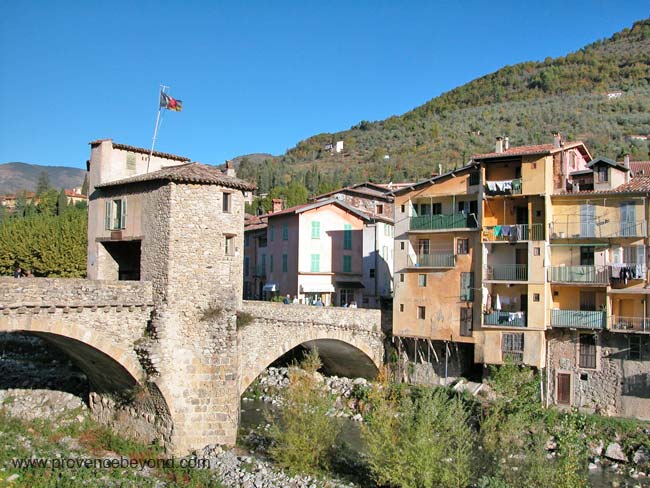
The main road crossed the Bévera by a fortified bridge (pont fortifié) built in the 12th century and used as a toll bridge for the travelers. This picturesque bridge, also called the "vieux pont", is a double-arched stone bridge with a covered guard tower in the center. The bridge [photo] was damaged in the Second World War, then rebuilt using the original stones. Until very recently (2004), the guard tower housed the Office de Tourisme.
Sitting astride the Bévera, Sospel is grouped into two distinct old-towns, one on each side of the river. The streets of the old town (both halves) are very narrow between the tall buildings, and they're very cool during the hottest summers. In general, the old streets are rather dingy and run-down, but with a distinct Medieval atmosphere and a feeling by Beyond that they're for practical everyday use rather than being abandoned. If the old streets aren't as pretty as many of the other Medieval Beyond villages, they're still interesting to explore, and you'll discover surprising things in your wanderings.
The highlights of Sospel for Beyond are: the river with it fortified toll bridge; the facades of the houses along the south side of the river; the Place Saint Michel with its cathedral and other surrounding buildings; the trompe l'oeil facades and sundials at various places around the town.
The southeast side of town (across the river) is the least interesting as far as touristic sites, but we like the main square, Place St. Nicolas, just past the end of the old bridge. Faded and un-restored, it's still picturesque and has a popular terrace café beneath the arches that's especially "authentic".
The Place Saint Michel is by far the most colorful and picturesque site in Sospel. The various facades around the square include the bright orange ocres of the multi-arched building now housing administrative offices and the bibliotheque municipale (town library), nicely restored and with its sundial. The imposing 17th-18th century Saint Michel cathedral, with its ornate carvings and the contrasting stone bell tower was restored in 1888, and retains its 1641 Renaissance facade and its 13th century clock tower.
A variety of other buildings, all interesting, but in varying states, from freshly restored and painted to ancient and faded, with old signs and markings giving a flavor of the past.
Driving
Sospel is a crossroads town, popular with cyclists, motorcyclists and fans of twisty-road driving. Even if you aren't a driving or riding enthusiast, the roads all have magnificent scenery and views of Beyond.
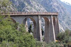
The most direct route up from the coast is the D2566 from Menton, or the A8 autoroute Menton exit. About 15 km, past Castellar and via Monti, you'll see the tall, curving structure of the Viaduc du Caramel where a narrow-gauge railway once passed.
From the center of Nice, or the Nice-Nord exit of the A8 autoroute, drive up the Peillon valley via l'Escarène and over the Col de Braus. About 40 kms this way, and the Col de Braus is famous with cyclist. The Nice-Cuneo railway line passes deep under the mountain, tunneled all the way from l'Escarène to Sospel.
Northwest from Sospel, the D2566 goes up through the Gorges de Piaon 24 km to the Col de Turini. This beautiful road is famous for automobile ralleys, including the Rally Monte-Carlo.
Northeast from Sospel, the D2204 goes 20 km up over the Col de Brouis to join the Roya Valley just north of Breil-sur-Roya. This is the main route to the upper Roya Valley and the lovely Beyond towns of Saorge, St Dalmas-de-Tende, La Brigue and Tende, or over the Col de Tende into Italy.
Olive Oil Mill
Sospel has a working "moulin à huile" just outside town, with a good reputation. We ran out of time on our last visit and didn't quite get around to seeing the mill.
Menton-Sospel Tramway
 A narrow-gauge tramway was built in 1913 to link Menton and Sospel. The tramway route followed roughly the route of today's D2566 road, north from Menton, past the little villages of Monti, the turnoff to Castellar, and Castillon. One of the few remaining parts of the tramway line still visible is the high, curved viaduct of Caramel about 10 km north of Menton.
Heading up the road, your first view is of a low, multi-arched viaduct crossing the road. Continuing up around the bend you see the main viaduct, sweeping out to the right over the valley, then curving back around to the left to eventually rejoin the hillside just where the road kinks back in another hairpin. A couple of km further up towards Sospel, the road bores through the mountain in a 1000-m long tunnel that was built for the tramway.
Maginot Line
About 3 km south of Sospel on the D2204 (the Col de Braus road) stands the of Le Barbonnet, once a part of the famous Maginot Line. An original Le Barbonnet fort was built on the 837 m high peak in 1883-1886. In 1932 the high fort was renovated and put into fighting shape. In 1940 the lower "gros ouverage" of the Maginot line was built, including a tunnel linking the two parts.
Today there's a small private museum with some quite interesting items and information and, interestingly enough, the fort is still occupied by the French Army.
There's a second, smaller fort built into the hilltop directly south of town. It's less than an hour's walk to the top, out the road past the railway station and the swimming pool.
History of Sospel
Name
First record, 1095 in loco Cespedelli
Ruled first by the Vintimille, then in 1258 by the Counts of Provence, and finally by the Counts of Savoy.
Prehistoric: Grottos with signs of prehistoric habitation were recently discovered.
Medieval:
Ruled first by the Vintimille, then in 1258 by the Counts of Provence, and finally by the Counts of Savoy.
In 1370, Sospel took the side of the Pope of Avignon and against the Anti-Pope in Rome, making the town church a cathedral.
Dates
Market day: Sat, Thur, Tue.
Apr - Fête des Mais - corn festival
June - Fete de la Musique in the Saint Michel cathedral
Hiking
• GPS: 43.877899, 7.447316
Maps
IGN (1/25,000) #3741 ET "Vallée de la Bévéra"
Didier Richard (1/50,000) #26 "Pay d'Azur"
Sospel is a great location for hiking: easy to get to from the coast, and full of a variety of hiking trails. There are five GR (Grande Randonnée) trails radiating out from the center of Sospel, and many other trails in the surrounding hills.
For a short pre-lunch hike, we walked out the road past the railway station and the swimming pool, following the yellow "petite randonée" marks, to a smaller Maginot Line fort on the top of the hill directly south of Sospel. First road, then forestry road, then trail. A great view of the town from the top, as well as lovely scenery along the way. We did have to move off the trail to let a couple of forestry department fire trucks trundle by; during the summer they position trucks and crews out in the hills.
Dining
Dining is rather poor in Sospel, in our opinion. Having visited a few time, and passed through a few more, over the years, we've not found a really decent place to eat.
There are some small café-restaurants, pizza places, and in the summer, a strip of terrace-restaruants along side the river. The view is nice and you won't go hungry, but the standards seem to be pretty low.
Comments contributed by Nico, May 2011
I then checked on Sospel, where I live. The description is very good but I noted your evaluation of local restaurants is not very positive. Should you do another visit any time soon, I would recommend to try 'le Relais du Sel'. My wife runs this place for a year now so don't take my word for it. Another restaurant worth trying is the 'Mordagne' . Pancakes and Savoie food, nothing fancy but very good value. Hope you will check soon and confirm there are actually some places worth eating in.
[Our last visit was a few years ago. We'll check it out again soon - Russ]
Sports
Just as in the 12th and 13th centuries, Sospel is an important staging point on the route into the mountains. Especially during the summer, when the population here triples, Sospel welcomes visitors for a variety of mountains sports (see also Hiking, below).
Hang gliding and para gliding (parapent)
Very popular here, with the landing zone immediately south of the town.
Swimming
A large open-air municipal pool (and a kiddies pool) located just outide town past the railway station.
Cycling
Sospel is a great location for a few days of road cycling in the mountains. There are excellent out-and-back and loop routes from Sospel.
The D2204 south over the Col de Braus (1002 m altitude) to l'Escarène is 22 km of good road and good hairpins. (The railway between l'Escarène and Sospel follows a straight line, deep inside the mountain far below the twisty road.)
The D2566 to the Col de Turini (1607 m) is 24 km with light traffic, but the road surface isn't great. The route goes up the Gorges du Piaon (along the Bévera river), past a waterfall by the Chapelle Ste Madeleine, the pretty chapel Notere-Dame de la Menour, and the little village of Moulinet.
The D2204 north over the Col du Perus (654 m) and the Col de Brouis (879 m) joins the Roya Valley 21 km from Sospel, and 2 km north of Breil-sur-Roya. From here to the Col de Tende (1279 m at the entrance to the tunnel) is 28 km, past the villages of Asorge, St Dalmas-de-Tende and Tende. It's a good road and with excellent scenery, but generally very full of motorized traffic.
Mountain Biking
There are great mountain-biking trails in the area, some directly in and out of Sospel and others in the hills out in the hills and further up the valley.
Fishing, Horseback Riding
Transportation Sospel
Bus
The TAM bus, line 910, has 4 buses a day (2 on Sundays) between Sospel, Castillon and Menton.
Rail
 The Train des Merveilles is a picturesque way to travel, and probably the easiest way to travel during the winter months if you're not used to driving on snowy mountain roads. The trip between Sospel and Nice is under an hour, with around 5 trains a day.


