

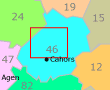
Montamel
• Lot (46310) • Population: 105 • Altitude: 380 m
Gallery of 8 photos for Montamel
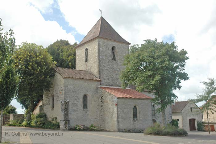
Montamel village is nice, but it's very little and there's not much here. Montamel does have a fine stone church, along with the few houses, and the surrounding farmlands make a nice view.
No village café, no commerce.
The open-sided barn (hanger) of a farmhouse in the village had its working equipment for all to see: trucks and combines that could have been in a museum.
The village church was built in 1768, and repaired in 1890.
History of Montamel
Montamel was ruled by the Guerre family until the 17th century, when it was ceded to the Gironde.
Hiking
• GPS: 44.606205, 1.448617
Maps
IGN (1/25,000) #2138 OT "Cahors NE, Vallee Lot-Cele"
Our 3-hour loop hike from Montamel was listed in the hiking guide as a 2-hour hike. And we didn't spend that much time exploring and photographing along the way. It is nice to look around, though.
The trail out of Montamel goes out past very pretty hamlet of Larroque, with a fortified farm-church and pigeonnier. Further along the hike the trail came out of the woods at the "hamlet" of Los Davadades, that was really just one farm.
Later, the trail passed the "hamlet" of Las Fargues, also a single farmhouse, this one apparently abandoned, although the adjacent farmland was obviously in use. There was quite an interesting pigeonnier on the side of the abandoned barn.
We did notice that the names Los Davadades and Las Fargues had a Spanish sound to them. Local signposts had the names translated to "Les ...".
 After 25 years online, I've decided to remove all Ads from my one-man web Provence Beyond. If the content is enjoyable or useful to you, I would really appreciate your support.