

Aiguilles
• Hautes-Alpes (05470) • Population: 449 • Altitude: 1471 m

Gallery of 20 photos for Aiguilles

Aiguilles is a mountain village on the Guil river valley in the Queyras Natural Park, northeast of Guillestre and past Chateau-Queyras. The village houses are grouped between the Guil river in front and steep, forested mountains behind. The main street through the village has houses, cafés, shops and even a tourist office. This small mountain village near Château-Queyras displays a strong South-American influence in its houses, following a 19th-century emigration and eventual return.
 Location.
From Château Queyras village, the road goes northeast up the Guil valley past Chateau-Ville-Vieille (3 km), Aiguilles (7 km), Abriès (12 km), Ristolas (15 km) and Ristolas-L'Echalp (19 km).
Location.
From Château Queyras village, the road goes northeast up the Guil valley past Chateau-Ville-Vieille (3 km), Aiguilles (7 km), Abriès (12 km), Ristolas (15 km) and Ristolas-L'Echalp (19 km).
Sundials
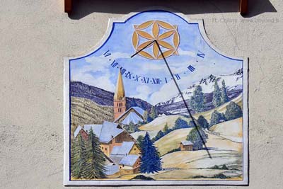 There are a dozen sundials in Aiguilles village, some of them quite nice.
At first glance there's a large, old sundial on the church steeple, visible from lower in the village. On closer approach, a very old, monochrome sundial with almost no image left, can be seen lower down on the church. At third glance, or with a second thought, the first "sundial" on the steeple is actually a clock with a single hand, in the style of a sundial
Of the other Aiguilles sundials, the "bee transhumance" one at the north end of the village is our favorite, and the monochrome "Mecano" one down at the west end has the most humorous legend.
History of Aiguilles
Tucked into the mountains and safely away from Provencal Saracens and the worst of the Wars of Religion, Aiguilles was unfortunately ravaged over the centuries by fire and flood.
The most serious floods occurred in 1408, 1431, 1957 and 2000. In years where a bit more rain would have been welcome, major fires occurred: 1594, 1629, 1746, 1829, 1886, 1889. The 1829 fire triggered the mass immagration to South America.
The "Republic of the Escartons" was established in 1343. In 1346, "L'Escarton du Queyras" joined France, but kept some special privelages. In 1789 the special "Escarton" privileges were abolished, and the the department of the Hautes-Alpes was created, adding the new cantons of Aiguilles and Abriès.
In 1685, following the revocation of the Edict of Nantes (that lead to making Protestantism illegal), all of Aiguilles' Protestant families moved away. The space was filled by Protestants and the Vaudois who moved into the Queyras region in 1689. In 1985, 300 years after the Edict of Nantes was revoced [sp], Protestant families returned to the Queyras.
In 1800, the seven communes of the Queyras were grouped together into the canton of Aiguilles (but Aiguilles remains one of the "communes" in that canton). In 1856 a road up the Valley of the Guil was built, an important event for Aiguilles, Abriès and Ristolas.
Hiking
• GPS: 44.784409, 6.867267
Maps
IGN (1/25,000) #3637 OT "Mont Viso, St-Veran, Aiguilles"
Transportation Aiguilles
Department 05, Haute-Alpes Buses
- See Beyond's Haute-Alpes (05) Bus Schedules for downloading Haute-Alpes bus-lines map and bus-line schedules [pdf for each line] (link for PDF files).