

Molines-en-Queyras
• Hautes-Alpes (05350) • Population: 308 • Altitude: 1762 m

Gallery of 13 photos for Molines-en-Queyras

The commune of Molines-en-Queyras is made up of several hamlets scattered along the mountain valley of l'Aigue Blanche and l'Aigue Agnelle, including Molines, Gaudissard, La Rua, Pierre-Grosse , La Coin and Fontgillarde. The hamlets are within a couple of km of each other, except Fontgillard that's a bit further out to the east. [Map
 Location.
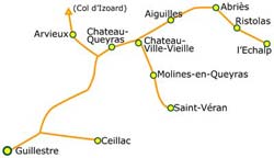
From Château Queyras village, the road goes northeast up the Guil valley 3 km to Chateau-Ville-Vieille (3 km). Southeast the D5 goes to Molines-en-Queyras (5 km from Ville-Vieille) and another 5 km to Saint Véran.
Location.
From Château Queyras village, the road goes northeast up the Guil valley 3 km to Chateau-Ville-Vieille (3 km). Southeast the D5 goes to Molines-en-Queyras (5 km from Ville-Vieille) and another 5 km to Saint Véran.
The architecture in this mountainous Queyras region is a steep-roofed stone house with a tall, multi-terraced wooden attic ("greniers à vent", or locally "fustes"). You'll also see a lot of all-wood buildings and barns. A picturesque touch is the wood fountains scattered about everywhere. Many are round wooden tubs with vertical slats, in the style of a barrel. Others have a basin of a wooden trough, either built of planks or, as we've found out in nature, carved out of a single log. Usually the spigots are metal, and sometimes terminated in carven faces or gargoyle-like heads.
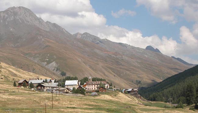
The mountains and valleys are magnificent, with gorgeous views and clear skies. The whistles of marmottes seem constant.
Saint Romain Church
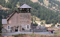 The Eglise Saint-Romain, located by the road junction between Molines and La Rua, dates originally from the 14th century. It was partially destroyed by the "white hats" (chapeaux blancs), the local reformation group of that era. It was rebuilt in the 17th-c (1628-35). The church is dominated by a huge stone tower with a unique, open wooden bell-tower at the top. At the corner of the church is a double sundial (two sundials on adjacent sides of the corner), dating from 1849.
Bread Ovens
Communal bread ovens are called "fours banals" in the mountains of the Queyras, and in years gone by every village and hamlet had its own. In Molines-en-Queyras there remain only three: one each in Molines, Fontgillarde and Le Coin, used regularly until the mid-50's. Some of the mills that provided the flour were carried away by the floods of 1957.
Fires
Picturesque wooden fountains with wooden basins can be seen in every section of every hamlet. These have been used, with only partial success, to combat the periodic fires that have occurred during the past couple of centuries. Major fires in the past burnt down all of Fontgillarde and another destroyed nearby Saint Veran.
Sundials
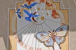 The theme itinerary of our trip is sundials, and there are many in the Molines-en-Queyras area, including some from the 18th and 19th centuries. Many, though, are fairly recent (1980s and '90s) and not as elaborately detailed as some of the ancient ones we've seen, but many of these newer ones are original and nicely done. Nearby St Veran has about 20 sundials, but we found a fair number here in the hamlets of Molines-en-Queyras.
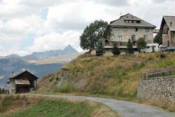
The Hamlets
Molines (1750 m)
The namesake hamlet, and "chef lieu" of the commune is small, but has lodging, a café with terrace, and a few shops, including a laundramat. Moline has an old communal oven ("four banal"), still used during village festivals, one of three left in the commune.
The most ancient thing we found in Molines was an arched stone doorway with a "1694" stone and a very ancient carved stone face.
We found one sundial, dated 1998; this is the Isabelle sundial, named for the owner, and for the rare night butterfly depicted on it.
 Fontgillarde (2030 m)
This tiny farming hamlet is up the Aigue Agnelle valley, a couple of km east of Pierre-Grosse and sitting just beside the river. The hamlet name is derived from "abondant fountain" (fontaine abondante, with gaillarde = abondante). This is the last hamlet on the road to the Col Agnel, the 2744 m high pass into Italy. Fontgillarde has a nice collection of old houses and farms.
We found six sundials here, dated from 1839 to 1988, and a couple undated. The 1839 sundial on the long Maison Tangente building is famed for being the only one in Fontgillarde to have escaped the fire of 1904 . Most of the villages and hamlets, built mainly of wood, succumed to fire over the years.
 Gaudissard (1850 m)
A very tiny hamlet a couple of minutes up the road (northwest) above Molines, with mainly modern little houses, a few more ancient chalets with the wooden "fustes", some old farm houses and a very large gites-hotel in an old building.
We found three nice sundials here, dated 1990 and 1998. One is the owls sundial on the gites-hotel, and the others are a pair, "comet" and "sun" on a lovely old farm house.
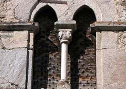 La Rua (1730 m)
This hamlet is located on the slope of the hillside, below the road that comes up from Guillestre, just below the main Molines hamlet. La Rua has a rich collection of the old buildings, including many with the wooden "fustes". We saw one house with a "fenêtre géminée" - a pillared window [photo].
At the top end of La Rua, the ancient Saint Romain church, with it's tall square bell tower, beside the road junction just below Molines. The pair of adjacent sundials on the corner of the church are undated, but obviously ancient. Their origins are uncertain, but the style of one is probably that of Zarbula, and it's partner sundial could be even older.
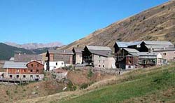
 Pierre-Grosse (1930 m)
More like a real village hamlet than La Coin, with narrow streets many old houses and farms. The center-piece is the white Chapelle St Sébastien, with its tall clock-bell tower and sundial [photo 8]. Pierre-Grosse has a school (école) and several gites. Along a village street a house had "1785" carved in the wooden lintel (inside the arched doorway).
The area villages are famed for the wooden fountains, and Pierre-Grosse has five of them.
We found six sundials here, many very nice, dated from 1991 to 1998.
 Le Coin (2010 m)
A lot of vacation chalets here, probably expanded from a little cluster of farms. The old hamlet is still there, at the top of the area, with the farms and a few of the traditional mountain houses.
We found three sundials in Le Coin, dated from 1988 to 2002.
Clot La Chalpe (1750 m)
This area at the base of the ski lifts we didn't recognize as a hamlet, but it is where the Maison du Tourisme is located.
History of Molines-en-Queyras
Name
First record, 8th century, Mullinaricii
Hiking
• GPS: 44.733333, 6.816667
Maps
IGN (1/25,000) #3637 OT "Mont Viso, St-Veran, Aiguilles"
Didier Richard (1/50,000) #10 "Queyras Pays du Viso"
The Queyras mountains are magnificent for hiking. The air is clear and the views breathtaking. Because of the mountains, small loop-hikes are fairly limited. Partially using the small roads, you can do loop hikes from Molines or Pierre-Grosse towards St Veran. There are also a couple of short loops west of Molines and La Rua. For other short (half-day or less) hikes, we did out-and-back from various spots; heading up the hillsides through the trees, then back down to the valleys.
There are some great long hikes in this area, including the Tour du Queyras and the GR58, that pass through St Veran, 3 km south.
Transportation Molines-en-Queyras
Department 05, Haute-Alpes Buses
- See Beyond's Haute-Alpes (05) Bus Schedules for downloading Haute-Alpes bus-lines map and bus-line schedules [pdf for each line] (link for PDF files).
Site Map Provence Beyond
After 25 years online, my one-man web ProvenceBeyond has gone completely ad-free — I would appreciate your support.
Nearby Places
- Abriès 15 km
- Aiguilles 10 km
- Arvieux-en-Queyras 14 km
- Briançon 46 km (via Col d'Izoard)
- Ceillac 30 km
- Château-Queyras 8 km
- Chateau-Ville-Vieille 5 km
- Embrun 48 km
- Guillestre 27 km
- Ristolas 19 km
- Saint Véran 5 km