Salernes
• Var (83690) • Population: 3,012 • Altitude: 300 m
Gallery of 19 photos for Salernes
Salernes is a small town in the Bresque valley, dominated by the ruins of it's 13th-century chateau, and famous for its ceramics, especially the little red "tomettes" [below]. The town is located in a lush valley surrounded by low hills, heavily forested with oak, pine and lots of olive groves. The surrounds also have many springs and grottos. There are also small cement quarries nearby, but none of this "industrial" activity detracts from the beauty of the village. • Market day Wed, Sun.
Walk around the village. There's a 35-minute walking tour of the village, marked with hand-made tile arrows painted bright yellow. The tour takes you through the little streets of the old village, and up past the ruins of the feudal castle at the top.
 The long central square, with its permanent lines painted for the market stalls, is shaded by rows of platanes, and has plenty of benches along both sides where you can sit and watch the activity.
For even more relaxed "watching", the terrace cafés along this square include the Bar-PMU l'Union, bar-restaurant La Bresque. Café du Cours and Café des Negociants.
There are plenty of other cafés in town, and one with a nice location is the Bierodrome, sitting beside the 13th-century church and across the street from the Office de Tourisme.
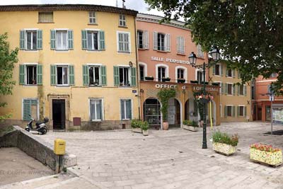
 The Office de Tourisme is in the old Mairie building, now painted a bright ocher, and including a permanent archeological exhibit.
The Mairie has moved into a new building on another large square, the Place Clemenceau.
When we visited back in May 1996, there was a fête for the kiddies at this square, with lots of animals, pony rides, and the fire department (pompiers) had rigged a special ride for the little kids, both fun and educational. Each kid was outfitted with a harness and a helmet, helped to climb the pompiers ladder up into a tree, and then slid down a rope to the ground.
Access
Salernes is located west of Draguignan; it's about 55-60 km from the beaches at Frejus/St. Raphael and about 25-30 km from Bauduen and the Lac St Croix. Salernes to Nice is 112 km, about 45 minute's drive.
Fountains of Salernes

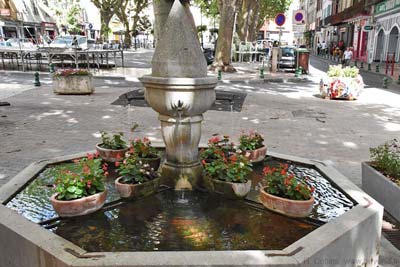
In the town you'll find some nice old stone fountains, including the 16th-17th-c one at the place de la Révolution with its octagonal basin and stone mascots, and the 18th-c double-spout fountain.
The Salernes tourist office has a map showing the locations of the town fountains, and trying to visit them all makes a good way to visit most of the village.
We also liked the old "lavoir" in Salernes.
 The town also has an old ruined mill along the edge of the Saint-Barthélemy creek, south of the village. At the northern edge of the town, beside the swimming hole (baignade) on the Bresque, is a very pretty donkey-backed bridge, the 17th-c Pont du Gourgaret.
The IGN hiking map shows a Roman bridge (pont romain) 1.5 km south of Salernes. We found the bridge, hidden in the woods and weeds, barely visible on the east side of the D31 road. It didn't look quite as old as Roman to us, but we're definitely not experts.
Church
The village church, Saint-Pierre, dating from the 13th century, is built in the Romanesque-Cistercian style, and faces the rising sun. The tower has two ancient clocks and is topped with a rather ornate 17th-century campanile, and an 18th-century sundial (cadran solaire).
Feudal Castle Ruins
Earliest available records show that the castle existed in the 12th century, and that it was captured by the Aragonais (from Spain-Pyrenees) in 1189. The castle was destroyed by a fire in 1676, over a century before the French Revolution (when many French castles were destroyed). The current 13th-century remains include towers, walls and ramparts.
Salernes Ceramics
 Salernes, like Vallauris in the Alpes-Maritimes, became a pottery center because of the natural deposits of clay (argile) rich in iron oxides, as well as the abundance of clear water and the forests to feed the fires of the kilns. The activity of the town is intense and is organized around the production of little "tomettes" - red hexagonal floor tiles - that are typical of Provence and are known worldwide.
 Prior to the 19th century Salernes had an agricultural economy, producing wine, olive oil, figs, wheat, peaches and melons, as well as some silk and hats. In the first part of the 19th century many small shops began producing various clay products for local usage, including bricks, tiles, pipes and pottery.
When the exceptional quality of the iron-rich clay became evident, they began specializing in a small red hexagonal floor-tile called "tomette". Around 1850, the "tomette" started developing into the principal product of Salernes, with important exports, first to the South of France, Toulon, Marseille and Nice, and then on to Italy and Africa and America. The "tomette" remained the main product of Salernes for a hundred years. It's still popular today, although from around 1950, Salernes began developing several new ceramic products, but still specializing in various floor tiles.
Beyond's own house has several examples, including some lovely decorative kitchen tiles (photo, left).
Today the Salernes ceramics tradition is maintained by 15 ceramists and 4 potters. Approximately 300 people work in its 15 factories.
History of Salernes
Name
First record, 1007 : Salerna. Etymologies possibles : "Salis terranum", salt of the earth, from sources of salty water ; or from the Pre-Celtic root "sal" for streams in deep cuttings.
From the beginning of the Middle Ages, a population centered here on the rocky hilltop, protected by fortifications and eventually the chateau, while the population expanded on the surrounding plains.
The Abbey of Saint-Victor owned Salernes in the 11th century, then the Lords of Pontevès until the 12th, followed by the Lords of Castellane who ruled Salernes until 1676, the year that castle burned down; Joseph de Bourbon d'Acigne was the occupant at that time. Gallien des Issarts then ruled, as a marquise, although the castle was never rebuilt. The Lords of Galiffet purchased the place in 1764 and ruled until the Revolution, about 25 years later.
In the 14th century, many Italians arrived, with Reine Jeanne (the 1st, of Anjou-Naples).
Prehistoric: Prehistoric signs and artifacts have been discovered in the area at Beaumes de Fontbregoua, Coumbo-Malo, and Goulon; the tumulus of Tholos at La Lauve [1 km north, on the south side of the road]; the shelter "Roches-Rouges"; a burial grotto. A Celto-Ligurian oppidum at La Mure. Traces of Gallo-Roman occupation at l'Estang, Gandelon [1.5 km northeast], La Mude, Les Grangues, and La Manserve [1 km east] (ceramics and tiles). Paleo-Christian sites at Saint-Barthélemy [2.5 km north], Saint-Loup, and Gandelon.
Dates
Market day: Wed, Sun.
Foire à la brocante: 2nd Sat
May (Beg) - Pèlerinage à Saint-Barthélemy
Aug - Fêtes votives de Saint Barthélemy
Sep - Fêtes votives de Saint Loup
Sep - Foire de la Sainte Catherine
Hiking
• GPS: 43.563658, 6.232306
Maps
IGN (1/25,000) #3443 OT "Aups Salernes"
One hiking trail begins at the northeast edge of town, beside the football pitch. This petite randonée (PR) trail goes north, following small roads, past the Chapelle St. Barthélémy (about 3 km), one of the Paleo-Christian sites. The trail continues north, through the forests, another 5 km to Aups.
Transportation Salernes
The nearest main-line train station is Draguignan-Les Arcs (rail map), which is close to Les Arcs, not Draguignan.
It's 28 km from Les Arcs to Salernes, either via Flayosc or Lorgues. There is bus service, but we don't have schedules, and there is taxi service.
Department 83, Var Buses
- See Beyond's Var Department Bus Schedules for downloading the Var bus-lines map [Plan du Reseau] and bus-line schedules [Horaires] (link for PDF files).
- Schedules for the Var bus lines are on the VarLib Horaires-Ligne page (http://www.varlib.fr/horaires_ligne/?rub_code=6") - type the line number in the Numéro ... ligne box to access the bus schedule PDF link. (Type a couple of digits in the box to get a list of route numbers.)
Les Arcs - Draguignan - Salernes - Aups Bus 1201
- Var bus line 1201 connects Les Arcs (Gare SNCF/TGV), Draguignan, Flayosc, Villecroze, Salernes, Aups.
Schedules for the Var bus lines are on the VarLib Horaires-Ligne page (http://www.varlib.fr/horaires_ligne/?rub_code=6") - type the line number (1201) in the Numéro ... ligne box to access the bus schedule PDF link. (Type a couple of digits in the box to get a list of route numbers.)


