

Aurel
• Vaucluse (84390) • Population: 158 • Altitude: 800 m

Gallery of 15 photos for Aurel

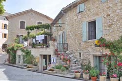
Aurel is a very pretty little perched village, with some of the steep village streets carved through the rock. A joined 12th-century church and 13th-c chateau sit at the top of the village.
The village sits in an area of wide valleys full of lavender fields and grain, and low forested hills, with a backdrop of the white-topped Mont Ventoux in the distance. The roads around here are great for scenic driving, and the village is definitely worth a visit.
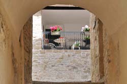 It's small enough that wandering the village streets doesn't take more than an hour or two, but some of the streets are steep enough to discourage anyone not comfortable walking.
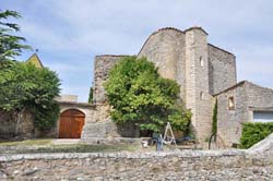 You can walk around the 13th-century chateau and the 12th-century church [Photo-11] at the top of the village, but these ancient sites are privately owned and not open for visits.
There are abundant fountains in the village for thirsty hikers and cyclists. The main one is in the center, beneath a shady tree.
Commerce
 Really minimal commerce is available in Aurel, with only one small general store in the center of the village.
Dining, Lodging
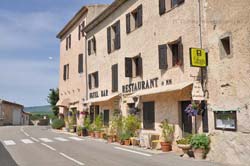 One centrally-located Hotel-Bar-Restaurant, the Relais du Mt Ventoux is quite nice, and very popular with cyclists. The shady terrace across the street from the front door is a pleasant place to relax in the afternoon heat.
History of Aurel
Name
First record, 1178 Castrum Aurelii
Founded in the 11th century by the Knights Hospitalers who built a hospice here. At the end of the 16th century, Aurel was captured by the Baron de Vins, allied with the Count of Sault.
Prehistoric: Prehistoric shelters were found in the nearby rocks.
Hiking
• GPS: 44.129102, 5.427183
Maps
IGN (1/25,000) #3240 OT "Bannon, Sault"
Didier Richard (1/50,000) #27 "Ventoux"
There are a fair number of hiking trails through and near Aurel. Most pass through some woodlands, but are largely through open fields, including lavender fields, grain and vineyards. The lavender fields are especially beautiful from the end of June to August, although afternoon hiking is pretty warm then.
It's about a 1-hour hike between Aurel and the north end of Sault on the GR91C (Grande Randonnée), and there's a magnificent view of the perched village when arriving along this trail from the south. [In June 2009 the GR markings were very faded, but the trail is obvious.]
The Aurel - Sault hike can be a loop, by using for the return trip one of two trails southwest of Aurel or the longer loop southeast of Aurel, via the village of Saint Trinit.
Transportation Aurel
Department 84, Vaucluse Buses
- See Beyond's Bus Schedules Page 2: Vaucluse Department for downloading Vaucluse bus-lines map [Plan global des lignes] and bus-line schedules [pdf for each line] (link for PDF files).
• Avignon has train or bus connections to Aix-en-Provence, Arles, Nîmes, Saint Remy-de-Provence, Paris.
• Cavaillon has bus connections to Aix-en-Provence, Arles, Saint Remy-de-Provence.
• Pertuis has bus connections to Aix-en-Provence and Marseille.