

Tourette-du-Château
• Alpes-Maritimes (06830) • Population: 89 • Altitude: 900 m
Gallery of 10 photos for Tourette-du-Chateau

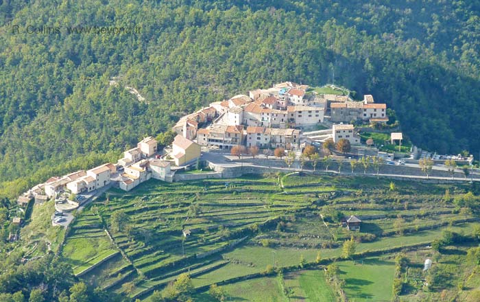
Tourette-du-Château is a pretty little village in a very lovely setting, but there's no chateau — and no café, no bakery, no commerce.
Tourette-du-Château is backed by a high mountain ridge with the Mont Vial peak, and stretched out to the south and west are endless forested hills and the distant Mediterranean. A lookout point at the top of the village offers this panoramic view, with a detailed ceramic point-of-view map [Photo-07].
The village is neat, clean and well maintained. In the center is the pastel colored 17th-century church with its tall bell tower [Photo-10] and an old fountain [Photo-05] in an open square.
There are a few village streets here for wandering, but the main interest is the setting and the view. Near the top of the village is Rue du Pontis, the only vaulted passage [Photo-09]. The main street along the northeastern (lower) side of Tourette is lined with plane trees [Photo-03], and has a pretty pastoral valley below, at the base of the towering Mont Vial chain.
In spite of the "-du-Chateau" part of the name there is no chateau here. It was destroyed in 1622 along with the fortifying walls.
Faded signs painted on the walls give testimony to missing bakeries and cafés [photos]. When we asked the first person we saw if there was a café we got the response "No. No café, no bread. This is a dead village." We agree only in the sense of commerce, but it's still a pretty place in a lovely setting.
History of Tourette-du-Château
Name
First record, 13th century Toretta
In 1400, Tourette-Reveste (which then included what is now Revest-les-Roches) was a fief of the Grimaldi de Beuil. In the 17th century, Annibal Grimaldi, Count of Beuil and governor of County of Nice, had a political falling out with Charles-Emmanuel, the Duke of Savoy. Annibal Grialdi retreated here to his castle of Tourettes-Revest. The castle was besieged by the Savoyard troops, Annibal was captured and strangled to death here in January 1621. The lands eventually passed into the hands of the Galleani's, and in 1734 to the Caissotti's.
In 1871 the eastern part of Tourette-Reveste was broken off to form the commune of Revest-les-Roches, and the name of the remaining lands were changed to Tourette-du-Château.
The population in 1858 was 385 inhabitants. In 1999 the population of Tourette-du-Château was 89 and that of Revest-les-Roches was 162.
Hiking
• GPS: 43.882367, 7.143441
Maps
IGN (1/25,000) #3641 OT "Moyenne Var"
IGN (1/25,000) #3642 ET "Vallée de l'Estéron"
Didier Richard (1/50,000) #26 "Pay d'Azur"
There are great hiking trails in the forested hills of this area between the Var and Esteron river, including Toudon, Tourette-du-Chateau, Revest-les-Roches and Gilette.
A loop hike around Mont Vial, north of the village, is described on our Revest-les-Roches page, along with mention of the Mont Lion hike just south of the village.
The PR trail from Revest-les-Roches and Toudon passes below Tourette-du-Château. There is a fountain here along the trail, but with non-potable water, so you'll need to go up to the village to fill your canteens.
West of Tourette-du-Château, short and long loop hikes go to the village of Toudon, and beyond that southwest to Pierrefeu or northwest to Villars-sur-Var.
 After 25 years online, I've decided to remove all Ads from my one-man web Provence Beyond. If the content is enjoyable or useful to you, I would really appreciate your support.