

Gilette
• Alpes-Maritimes (06830) • Population: 1,024 • Altitude: 459 m
Gallery of 11 photos for Gilette

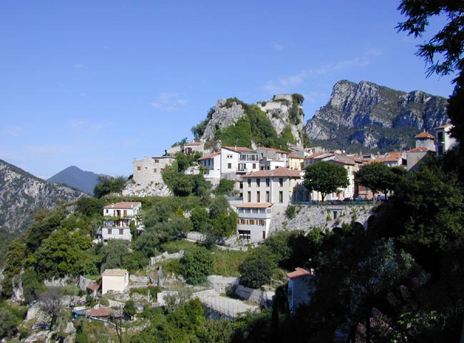
This fairly interesting village sitting in a saddle of the hills high over the western side of the Var river. Many of the village streets are picturesque, including the ones leading up to the ruins of the chateau on the peak above the village. It's only a short climb/walk up to the old ruins, and a magnificent view from the top. It's up here we found the tall, carved wooden statue of "l'amitié (friendship).
A fairly interesting village sitting in a saddle of the hills high over the western side of the Var river. Many of the village streets are picturesque, including the ones leading up to the ruins of the chateau on the peak above the village. It's only a short climb/walk up to the old ruins, and a magnificent view from the top. It's up here we found the tall, carved wooden statue of "l'amitié (friendship).
Gilette isn't really an attraction for tourists, but it's worth a short visit if you're passing through on this road into the Esteron valley.
There are a few village shops to serve the local inhabitants and passing visitors, including a modern pharmacy.
The day we went there for a proper visit (after having passed through several times with no more than a brief stop), there was a "brocant - vide grenier" market at the village. That brought all the inhabitants out together, with every old trinket, treasure, toy, antique or piece of clothing they could find to sell. It made a fun atmosphere whether you were in the buying mood or not. We particularly liked a pair of ancient wooden skis and thick wooden ski poles.
History of Gilette
Name
First record, 1079 Gelata
This was an ancient fortified village, with the castle listed in 1232. In 1793, Dugommier won an important, and unexpected, victory over the Austo-Sardaniens.
Hiking

• GPS: 43.850309, 7.163388
Maps
IGN (1/25,000) #3642 ET "Vallée de l'Estéron"
Didier Richard (1/50,000) #26 "Pay d'Azur"
There are many Petite Randonée (PR) hiking trails, either directly from the Gilette or nearby in the surrounding hills. The PR trails are flagged with bright yellow marks, but because different trails can join and separate, you should have a map. Trail markers (bornes), like this #2 one in our photo, are also on the IGN maps.
We rather liked the doggy sign next to the hiking marker. Hopefully it doesn't mean you need to watch your step down that trail.
With a mixture of the many hiking trails and country roads, you can find different loop hikes for a variety of times.
Dining
The bar-pizzeria up on the Place de la Fontaine, above the main road, wasn't serving meals on Sunday, and didn't look that great as a place to eat. It's a fine café, though, with terrace tables on the square.
Sports
Swimming
About 4.5 km up the road towards Pierrefeu and Roquesteron, 700 m past the hamlet of Collebelle, a trail leads down to the river at the Pont Payré, where there's a swimming hole.