

Roquesteron
• Alpes-Maritimes (06910) • Population: 509 • Altitude: 340 m
Gallery of 3 photos for Roquesteron

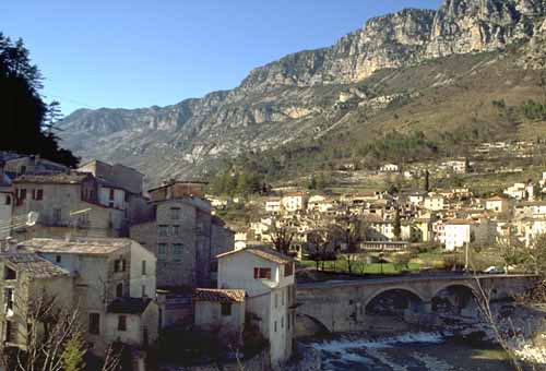
There are actually two separate communes here straddling the Esteron river, in a long valley isolated from the Var river to the north and Grasse to the south. Roquesteron is on the left bank (north side) and Roquesteron-Grasse is on the right bank (south side). In our photo, the houses in the foreground, at the left, are in Roquesteron-Grasse, and the houses on the far hillside are in Roquesteron. • Market day Sun.
On the north bank of the Esteron is the old village of Roquesteron, between the river and the main road. The houses are ancient and the streets are steep and narrow, with some serious vaulted passages. The village actually passes underneath the main road, and down between the old buildings is a warren of tunnel-streets.
The commerce is along the main street, with the church, post office, an antique shop, a café, an alimentation, boulangerie and a café-restaurant-hotel. Except for one small restaurant just below the main road, there's no commerce down in the old village. Above the road is the newer part of the village, with villas and apartments spreading up the hillside towards the cliffs of Mont Long.
On the south bank of the Esteron is the even older village of Roquesteron-Grasse, perched on the rocks at the bend of the river, facing the valley where the river Rieu flows in from the east. There's a small post office for this side, and some very ancient houses clinging tightly to the rocks that rise up to the peak where the Chapelle Ste-Pétronille is perched. An auberge is perched on the edge of the river, giving its dining room, and especially its outdoor terrace, a fantastic setting over the water.
The double village of the Roquesterons is quite large, but with very little commerce and just about nothing to attract tourists. In spite of its beautiful setting and its size, it seems to be a bit too calm.
History of Roquesteron
Name
First record, Roquesteron-Grasse, 1028 La Rocca; La Roque. Roquesteron would be, then, the rock on the Esteron. Accents: early documents have the name spelled with an accent on the final e (Roquestéron), but in later documents and maps there is no accent.
Gallo-Roman: An ancient castrum was located at l'Olive, in the hills about 1500 m south of the village. There are also Roman funeral engravings in the northern village.
Medieval: The original fortified village was on the rocky promontory of the right bank, with it's 12th century Romanesque church perched above and a chateau at the top (now gone). In the less-perilous times of the end of the 15th century, the village extended across the river to the north, the area being called Roquesteron-Puget.
More Recently: The two halves, separated by the river, were part of the same commune until the Treaty of Turin in 1760. The new frontier along the river separated them into Roccasterone, or La Roque-Savoyarde, on the north side (in Italy), and La Roque-en-Provence on the south side (in France).
Dates
Market day: Sun. Sun Market May-Oct
Hiking
• GPS: 43.874321, 7.005376
Maps
IGN (1/25,000) #3642 ET "Vallée de l'Estéron"
Didier Richard (1/50,000) #26 "Pay d'Azur"
This is a great region for hiking, with the thickly forested hills and the lovely rivers, but it can be steep. The GR510 (Grande Randonnée) runs through the center of Roquesteron.
From the south side of the bridge, the GR510 goes west through the hills, and then climbs up to the village of Sigale. It continues northwest to the Clue du Riolan and on to the Montagne des Miolans (984 m).
From the north side of the bridge, the GR510 climbs northeast past Cuébris (600 m) to the Crête des Gauthiers (814 m), then crosses the hills northwest to descend into Puget-Théniers (410 m).
There are several other local hikes, some without end: trails cross the mountains to the south, over the 1768-m Montagne du Cheiron; west up the Esteron valley to join the GR4 hiking trail; and northeast, east and southeast through the hills for as far as you could want.
Sports
Canoeing, fishing and microlight aircraft.