Comps-sur-Artuby
• Var (83840) • Population: 272 • Altitude: 900 m
Gallery of 13 photos for Comps-sur-Artuby
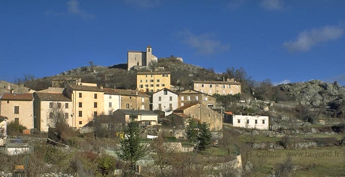
The village of Comps-sur-Artuby sits in a wide pass in the hills, only a few km south of the Verdon Gorges and on the northern edge of the vast Canjuers military camp. Comps-sur-Artuby was originally a perched village, but after its checkered history it settled into its current location. • Market day Tue.
Bridges |
Comps-sur-Artuby has a pleasant charm, especially when wandering through the narrow back streets that flow out over the adjacent hills with their churches and chapelles.
Inside the village, with plenty of shops and stores of all kinds, the buildings frame little squares and fountains, and some buildings are painted in bright, contrasting pastels, looking fresh and friendly. Outside the village, wide paths take you to views of hills forested with Scots pine and beech, accented with long, deep gorges walled with low cliffs of white rock.
There are plenty of churches and chapelles, including the 12th-century romanesque church called the Templiers, the romanesque chapelle St-Jean and the Provençal-Romanesque chapelle St-Didier.
Churches and Chapels
Saint-Philomène
The main church of today's Comps-sur-Artuby, St-Philomène is on the Place Notre-Dame at the edge of the village, just past the Place de la Fontain. Inside is a 17th-century tableau representing "la vision de Saint Dominique".
Saint-André (Templiers)
The Romanesque Saint-André parish church was built in the 13th century, when the Commanderie des Hospitaliers (Knights Hospitalers) was in Comps. Called the Chapelle Saint-André on local signs,and rebuilt in 1839, Saint-André was originally fortified on the hilltop where the original village was located. The bells date from the 15th and 16th centuries. [Photo-09]
Saint-Jean
The Romanesque Chapelle Saint-Jean, located on a ridge at the east end of the village, was built by the Hospitalers. [Photo-08]
Saint-Didier
The Romanesque-Provençal Chapelle Saint-Didier, also built by the Hospitalers, is located out on the west side of the village, near the road to Castellane.
La Souche Hamlet
This little hamlet is located about 2 km northeast of Comps-sur-Artuby village. across the field on the north side of the D21 road. It's a very small hamlet, now mostly residential, in a very pretty setting. The hamlet's Fontaine de la Souche [Photo-11] is an ancient fountain-lavoir-bouvoir complex that provided the first water here, before being channeled on to the central fountain and the fields.
Roman Bridge
The multi-arched stone "Roman" bridge [Photo-12] at the edge of La Souche hamlet is certainly in the Roman style, but was actually built in the 17th century. It's a lovely place to wander and to wade in the stream.
This long, stone bridge with its multiple arches and curved lines reminds us of the Medieval Vins-sur-Caramy Bridge 40 km to the southwest in the Central Var.
History of Comps-sur-Artuby
Name
First record, 11th century in Cumbis
Prehistoric: There was a chalcolithic and an iron-age presence in Comps.
Medieval:
Comps was controlled by the Hospitalers (Knights Hospitalers) in the 13th century.
Charles de Duras laid siege to Comps. When he finally conquered it, the inhabitants fled, eventually creating a number of smaller hamlets nearby.
After a donation by the Reine Jeanne, Duras shared control of the domain with the Pontevès.
Comps was the home of Arnaud (1163) and Bertrand (1244), both grand masters of Malta. Another luminary of Comps was père Pellas, who in 1723 wrote the first Provençal dictionary.
Hiking
• GPS: 43.709689, 6.508488
Maps
IGN (1/25,000) #3543 OT "Draguignan"
Didier Richard (1/50,000) #19 "Haute Provence Verdon"
The GR49 passes east-west along the Jabron river, about 3 km north of Comps.
There are several local hiking trails, some marked with a blue blaze rather than the traditional yellow, and the trails cross through the Foret de Duou to the east and the Bois de Fayet to the west.
Going west from the village there are different loop hikes through the woods, from one to three hours.
A nice walk-hike to the east starts with a visit to the hilltop Saint-André church and then the Saint-Jean chapel (about a half hour for both). Then a trail goes east down a shady valley to an old factory area with shady picnic places and a fishing stream [Photo-10], about 2 minutes. From here you can walk north, crossing the D21 road, to La Souche hamlet (10 minutes), and on to the "Roman" bridge (10 minutes).
Sports
Bungee Jumping
Reader Nathalie tells us: Pont de l' Artuby 182m the greatest jump of Europe!!.
The Pont de l'Artuby is 15 km west of Comps-sur-Artuby, on the D71 road. Twelve km west of the village is the Balcons de la Mescla, a wonderful and popular lookout point on the south rim of the Gorges de Verdon. Three km further south, the road crosses the Artuby river over a deep canyon, and here you'll find the bridge.
Transportation Comps-sur-Artuby
Department 83, Var Buses
- See Beyond's Var Department Bus Schedules for downloading the Var bus-lines map [Plan du Reseau] and bus-line schedules [Horaires] (link for PDF files).
- Schedules for the Var bus lines are on the VarLib Horaires-Ligne page (http://www.varlib.fr/horaires_ligne/?rub_code=6") - type the line number in the Numéro ... ligne box to access the bus schedule PDF link. (Type a couple of digits in the box to get a list of route numbers.)


