

Aix-en-Provence Historic Itinerary Northwest
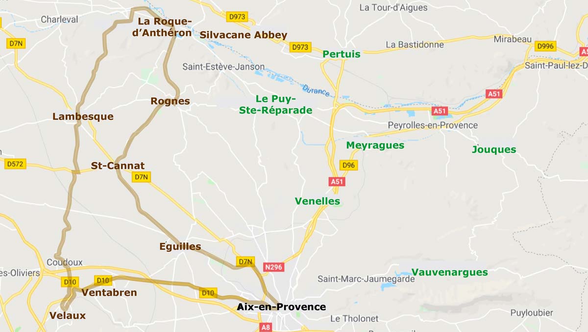
This itinerary visits eight villages of historical interest to the northwest of Aix-en-Provence. The route is a loop, with a total distance of 89 km (about 2hr15 driving time).
Aix West Map | Aix NE | Aix SE | Aix South Aix NW | Aix Martigues | Aix St-Remy | Aix Verdon | Surrounding Aix-en-Provence |
 Our favorites in this area are the Jacquemard clockwork tower in Lambesc and the Silvacane Abbey beside La Roque-d'Anthéron.
Aix-en-Provence to Ventabren
Route. [16 km, 27 min]
Depart Aix to the west on the D10 (Route de Berre) to Ventabren.
Ventabren to Velaux
[6 km, 11 min]
West from Ventabren (either N to the D10 or SW to the D65), via Moulin-du-Pont to Velaux.
Velaux to Lambesc
[18 km, 28 min]
Return north to the D10 at the Moulin-du-Pont roundabout, then left (northwest) on the D10 about 1.5 km; Right (north) on the D67E through Coudoux, via Les Quatre Termes to Lambesc.
Lambesc to La Roque-d'Anthéron
[10 km, 18 min]
Due north from Lambesc on the D67, directly into La Roque-d'Anthéron.
La Roque-d'Anthéron to Silvacane Abbey
[1 km, 2 min]
The Abbey is just over 1 km east of town, on the D561A. The parking area is just beside the road, on the north side. It's only a short walk from the parking area to the Abbey grounds.
Silvacane Abbey to Rognes
[10 km, 12 min]
Head east from the Abbey on the D561A.
(b) In 1 km, the small D66E branches right, past a lake, and joins the D543 south to Rognes.
(b) Or, at about 3 km east of the Abbey on the D561A, (in the hamlet of St-Christophe) turn right onto the D543 south, which passes on the other side of the little lake and continues to Rognes.
Rognes to Saint Cannat
[7 km, 11 min]
West out of Rogne, then immediately left (southwest) on the D18 to Saint Cannat.
Saint Cannat to Eguilles
[8 km, 10 min]
Go south from the center on Ave Victor Hugo, which becomes Route de Saint-Cannat (D18) going southeast to Eguilles.
Eguilles to Les Figons
[3 km, 6 min]
Northeast from the center out the D17 for 500m, then turn right (southeast) onto the Route d'Aix-en-Provence to Les Figons.
Les Figons to Aix-en-Provence
[9 km, 14 min]
Southeast to Aix-en-Provence; either from the north of the village, join the route d'Avignon (D7n); or southeast from the village on Route d'Eguilles that joins the D17 into Aix.
 After 25 years online, I've decided to remove all Ads from my one-man web Provence Beyond. If the content is enjoyable or useful to you, I would really appreciate your support.