Le Tholonet
• Bouches-du-Rhône (13100) • Population: 2,266 • Altitude: 193 m
Gallery of 10 photos for Le Tholonet
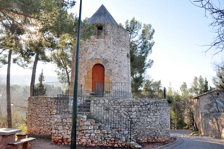
Le Tholonet is a micro village; there's nothing here in the way of shops, but it was a favorite place of Cézanne. There are two nice café-restaurants with terraces, a picturesque little church, a 17th-c chateau and a bladeless windmill with a backdrop of Sainte-Victoire mountain.
Cezanne |
The old village of Le Tholonet is located 5 km due east of Aix-en-Provence, and about 2 km north of the N7 highway and the autoroute. Along the N7 highway, southwest of the old village, is the hamlet of Palette; this is in the commune of Le Tholonet.
Le Tholonet village is mainly a starting point for a lot of hikes into the Sainte-Victoire mountain.
The 17th-century chateau of Le Tholonet is now the headquarters of the Canal du France. The parkland facing the chateau is lined with ranks of impressive old platan trees.
Roman Aqueduct
A Roman aqueduct is apparently located in the Cause ravine, in the hills just north of Le Tholonet village. We haven't visited this site yet. The Wikipedia page for Le Tholonet states:
Ruins of the Roman aqueduct that brought water from Saint-Antonin to Aix-en-Provence. This fifteen-kilometre aqueduct bridge, located in the Cause ravine, had a rate of nearly 80 liters per second and was one of four aqueducts that supplied Aquae Sextiae, Aix-en-Provence during the Roman period. The Aix painter Jean-Antoine Constantin drew sketches of it, which are now in the Aix-en-Provence Méjanes libraries.
Ruins of a Roman dam (Barrage Romain Ruines) are located a the bottom edge of the hill immediately north of the chateau of Le Tholonet. The shortest trail to the dam goes up a small road to the left (west) of the chateau.
Cézanne
Cezanne was in and through Le Tholonet often, painting local scenes. A stone marker between Le Tholonet and Aix-en-Provence marks the place where he painted his 1885-87 oil of Mont Saint-Victoire.
History of Le Tholonet
Name
First record, 1118 Tullonum; 1191 Castrum de Tullone; 1666 Le Tholonet
Prehistoric: There was Iron Age occupation in Les Espinades and Les Infernets ranges, 1 km north of the current village. These sites are on the south and north sides (respectively) of the little Lac Zola. At the northern site, Les Infernets, a small oppidum named "Ragabom camp" or "Ratabom camp" was discovered, with Bronze Age pottery; today the ruins are barely visible.
Gallo-Roman: There are traces of a Roman aqueduct, remains of a dam, burial urns, and traces of the Roman Aurelian Way (Voie Aurélienne) in the area around the chateau.
Medieval: Le Tholonet was a fief of the Archbishops of Aix until the 13th century. It passed to the Jarente at the end of the 13th-c, who built a dam in 1475. Le Tholonet was ruled by the Albertas in the 16th-17th centuries, then sold in 1637 to the Gallifet. Alexandre de Galliffet built the Chateau de Tholonet (in its current form) in the 1640s.
Hiking
• GPS: 43.521896, 5.511195
Maps
IGN (1/25,000) #3244 ET "Ste Victoire, Gardanne, Trets"
Didier Richard (1/50,000) #14 "Luberon, Sainte-Victoire"
![]() There's great hiking here, directly from Le Tholonet village, into the hills at the western end of the Montagne Sainte-Victoire. There's a hiking information booth at the main village parking area [Photo-07], with a map of the local hikes.
Hiking trails head north, from left (west) of the chateau or from the tiny road beside the windmill at the east end of the village. Different loop hikes pass by the ruins of the Roman dam (just behind the Chateau de Tholonet), around the Lac Zola and the Zola dam, by the Bibemus quarries made famous by Cézanne, or a bit further to the Lac du Bimont and the Bimont (or Rigaud) Dam.
There's great hiking here, directly from Le Tholonet village, into the hills at the western end of the Montagne Sainte-Victoire. There's a hiking information booth at the main village parking area [Photo-07], with a map of the local hikes.
Hiking trails head north, from left (west) of the chateau or from the tiny road beside the windmill at the east end of the village. Different loop hikes pass by the ruins of the Roman dam (just behind the Chateau de Tholonet), around the Lac Zola and the Zola dam, by the Bibemus quarries made famous by Cézanne, or a bit further to the Lac du Bimont and the Bimont (or Rigaud) Dam.
Some of the other hiking trails here go east, to the Sainte-Victoire mountain, including to the top ridge, including to the Croix de Provence at the top. If you intention is specifically to hike Sainte-Victoire, there are closer starting points 4 or 5 km to the east of Le Tholonet on the D17 road.
Dining
There are two café-restaurants in the center of Le Tholonet village. Le Relais Cézanne has a large interior, and a terrace beside the road; it was named the Berne when Cézanne used to eat here. La Plantation - Chez Thomé sits back from the road, with the terrace tables beneath the trees (Cosed from early January to early February.)
Transportation Le Tholonet
Bus Le Tholonet
Le Tholonet is served by Proxi Bus line 3 of Aix-en-Provence. Line 3 connects Jas de Bouffan (Four d'Eyglun) on the west side of Aix, via Rotonde Bonaparte in the center of Aix, Val St Andre, Palette and La Tholonet (La Crémade).
Department 13, Bouches-du-Rhône Buses
- See Beyond's Bouches-du-Rhone (13) Bus Schedules for downloading Bouches-du-Rhone bus-lines map and bus-line schedules [pdf for each line] (link for PDF files).


