

Mane
• Alpes-de-Haute-Provence (04300) • Population: 1,135 • Altitude: 500 m
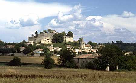

Mane is a small perched village, just 3.5 km south of Forcalquier. Apart from this lovely little village, there are a number of nearby sites worth visiting for their beauty and their historical interest. • Market day Sun.
The "Pont Romain" across the river southwest of the village is a Romanesque bridge dating back to the 11th century.
The Château de Sauvan is 18th century.
The nearby Prieuré de Salagon is a ancient and beautiful site, worth a visit.
History of Mane
Name
First record, 1103 Manoa
Gallo-Roman: This was an important crossroads throughout antiquity, and the Roman road "Voie Domitienne" that crossed the planes here is lined with aqueducts and necropoles.
Medieval: Ruled by the Viscount of Reillanne in the 14th century, then by the Lords of Agoult, the Bouliers and the Forbin. The Benedictine abbey was destroyed during the Wars of Religion.
Dates
Market day: Sun.
June (after 10th Sun) - Fête votive de la St Laurent
Hiking
• GPS: 43.93735, 5.766363
Maps
IGN (1/25,000) #3342 OT "Manosque, Forcalquier"
Didier Richard (1/50,000) #28 "Montagne de Lure, Val de Durance"
The GR6 Hiking Trail passing through Mane goes north to Forcalquier, St. Etienne-les-Orgues and the Montagne de Lure. To the west, the GR6 goes to the Observatoire de Haute Provence and then towards the Vaucluse.
Transportation Mane
Department 04, Alpes-de-Haute Provence Buses
- See Beyond's Alpes-de-Haute Provence (04) Bus Schedules for downloading Alpes-de-Haute Provence bus-lines map and bus-line schedules [pdf for each line] (link for PDF files).