

Champtercier
• Alpes-de-Haute-Provence (04660) • Population: 527 • Altitude: 700 m
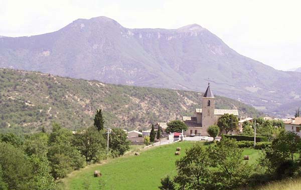
Gallery of 3 photos for Champtercier

The little village of Champtercier is in a lovely setting, only 10 minutes drive from Digne-les-Bains. Next to the village is a vacation community, a small observatory and the very lovely Parc Rural de Haute-Provence.
The village, however, is sleepy to the point of being moribund. It's neat and well-tended, but there's a single café, with questionable opening hours, and no apparent commerce or activity. When we visited, on what should have been the busiest weekend of the year (July-Aug transition), calm and silence were the order of the day. Champtercier appears to be a very pleasant place of residence for people working in the Digne area.
The vacation community is the Chadourene "Village de Vacance", located on the hillside near the entrance to Champtercier, with tennis courts and a large swimming pool.
To the north of Champtercier is a beautiful 20-minute drive to the picturesque village of Thoard.
Parc Rural de Haute-Provence
This rural, forested park area is located just before the village (coming from Digne). The park includes a bergerie (sheep farm), lavender distillery, chapel, olive-oil mill an pigeonnier (dovecote), as well as an auberge restaurant. The park is layed out with shady walking trails connecting the different parts, and a pretty stream running through the woods.
- Tel: 33+ (0) 492 31 90 80
- Open, May-June: Sun 12h-19h
- - July-Aug: daily except Mon 12h-19h
- - Sept: Sat-Sun 12h-18h
- - Oct: Sat-Sun 12h-17h
- Auberge dining, Menu 100 F; 60 F kids
- - July-Aug: daily except Mon 12h-19h
History of Champtercier
The land was given by Queen Jeanne in 1348 to Guillaume de Beaufort.
Gallo-Roman: Gallo-Roman tombs were discovered in the village and nearby at Ste-Colombe and Les Couertes.
Medieval: Ruins of medieval habitation (the site of the earlier village) are located at Oise, about 2 km to the west, on the southern flank of the tall rocky Pic d'Oise.
Hiking
• GPS: 44.092024, 6.149082
Maps
IGN (1/25,000) #3340 ET "Digne-les-Bains, Sisteron, Les Mées"
Didier Richard (1/50,000) #1 "Alpes de Provence"
Didier Richard (1/50,000) #19 "Haute Provence Verdon"
There's not much in the way of marked hiking trails in the area immediately around Champtercier. There is a single out-and-back trail from the villate to the east, across the fields and up to the 703-m peak in the woods 1-1/2 km east of the village.
Transportation Champtercier
Department 04, Alpes-de-Haute Provence Buses
- See Beyond's Alpes-de-Haute Provence (04) Bus Schedules for downloading Alpes-de-Haute Provence bus-lines map and bus-line schedules [pdf for each line] (link for PDF files).