

Aspremont
• Alpes-Maritimes (06790) • Population: 1,496 • Altitude: 530 m
Gallery of 10 photos for Aspremont

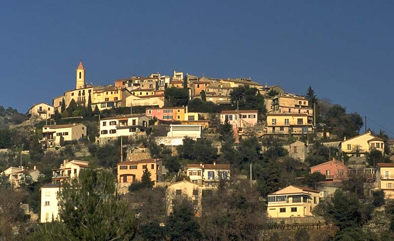
Aspremont is a picturesque perched village with the houses tightly circled around the hill in concentric circles, and even the gardens and orchards are ringed around the lower part of the hill in circular terraces. Only a few km from Nice and sitting above the built-up Var river valley, Aspremont is on the edge of wilderness. The village is surrounded on the south, east and north by wild country. Mont Chauve, topped by a fortress, towers to the southeast at 853 m, and the 878m high Mont Cima is just to the north. • Market day Wed, Sat.
 Inside the old village, neatly paved streets go up between the ancient houses and past paved squares, sometimes passing through arched tunnels beneath the buildings. At the top, the highest point of the village is occupied by an enclosed playground, showing the priorities of the villagers for the children.
At the road junction below the old village, a collection of shops and cafés with outdoor terraces welcome the traveller, and a lovely 17th-century chapel stands prominently at the center.
Arriving from the east, from Tourrette-Levens and the Col d'Aspremeont, the village of Aspremont seems to be standing guard over the hills behind it, as it towers high over the broad Var river valley stretched out below.
If the neat refurbishing of this medieval village seems to take away the feeling of antiquity, the ruins of an even more ancient village high on a hilltop to the north adds the proper historical perspective. If you take an extra hour to hike up there, on the GR5 trail, you'll see the ruins of an entire village, with the remains of a castle, courtyards and a donjon.
History of Aspremont
Name
First record, 1062 Aspermun
Both protohistoric and Gallo-Roman habitations were located here.
Medieval: in 1252 Aspremont was part of the fief of the counts of Provence, and then passed successively to Châteauneuf, Chabaud, Marquesan and Borriglione.
Dates
Market day: Wed, Sat.
July - Fête patronale
Sep (End) - Foire aux antiquaires et brocante
Hiking
• GPS: 43.783897, 7.243443
This area is either normally too rugged or too built-up for good local hiking, but Aspremont is at the junction of two principal Grande Randonnée trails: the GR5 that goes north from Nice up through the Parc du Mercantour, and the GR51 - Balcony of the Cote d'Azur.
For an interesting local hike, take the GR5 north out of the village and then branch off to go up to the Mont Cima (878 m). You'll see the ruins of a medieval village, grottos (including the Grotte de la Balme d'Arena, which unfortunately is marked by modern vandals), and a breathtaking view.
To find the GR51 towards the west, take a small lane south out of the village to where it crosses the road to the left (east) side and follows the road marked "Ancien Chemin de Colomars N° 1".
The other trails are a short ways northeast of the village, on the road towards Tourrette-Levens, at a junction with the Chemin de la Vallier (for the GR51 east and GR5 south) and the Chemin du Campoun (for the GR5 north).
Nice-North - Aspremont Hike
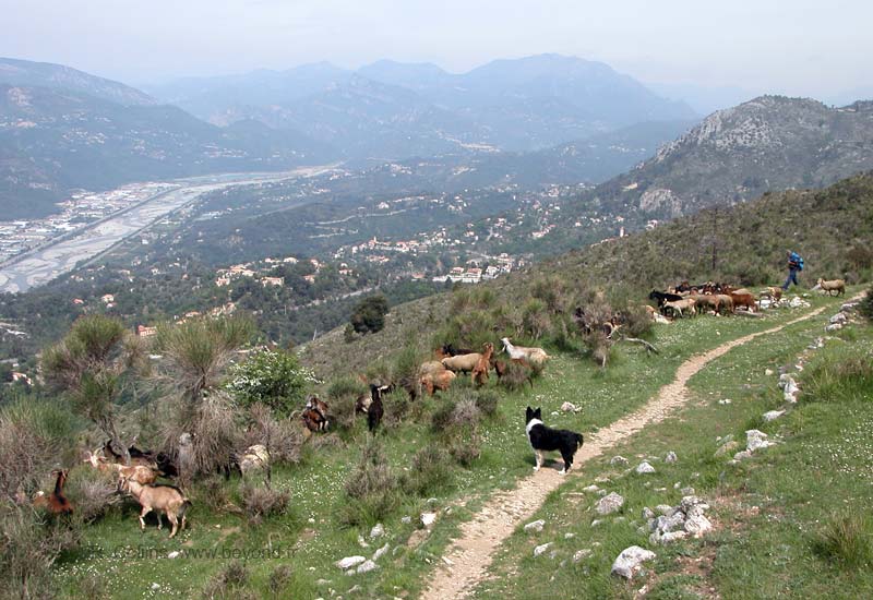
We've found an interesting hike between the north of Nice and Aspremont village. The trip was 3-1/2 hours north to the village, a nice visit and a lunch, then 2-1/2 hours return south. Our trip north included a side visit to the Ratapignata Pyramid , and later passing a shepherd and flock [Photo-10], like a time-shift into an ancient, rural past.