

Capitelles of Blauzac
Circuit des Cabanes de Blauzac

Gallery of 12 photos for Bories Blauzac

Blauzac, a small village in the Languedoc-Roussillon region, close to the town of Uzès, has around 50 nearby capitelles (the dry-stone huts know elsewhere as bories).
A well-marked walking route follows country lanes and shady trails through the woods, passing beside or near a fair number of these interesting capitelles.
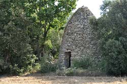
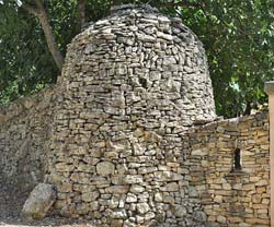
 The dry-stone structure in the top photo is the Cabane de Guiraud, typical of the capitelles you'll see in this area. They are often several meters tall, conical in shape (either rounded, or squared like this one).
The Cabane de Guiraud sits beside a dusty country lane, facing out across a vineyard.
[Map coordinates 43.974910, 4.373336]
The dry-stone structure in the top photo is the Cabane de Guiraud, typical of the capitelles you'll see in this area. They are often several meters tall, conical in shape (either rounded, or squared like this one).
The Cabane de Guiraud sits beside a dusty country lane, facing out across a vineyard.
[Map coordinates 43.974910, 4.373336]
Our photo here (left) shows the approach to this capitelle from the southeast, with signpost in the foreground indicating the various hiking/walking trails available.
Route of the Circuit des Cabanes de Blauzac
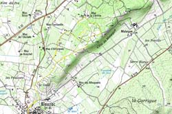 On our map image, the yellow line shows the walking route northeast from the center of Blauzac village and looping out through the area of the capitelles.
A more detailed map, showing the location of the individual capitelles on the "Circuit des Cabanes de Blauzac", is available on the Pierre Seches website .
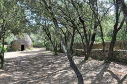
 We found this tall cabane sitting in the trees at the edge of a field. The field wasn't planted at the moment, and we were careful to skirt around the edge to visit the site. It's entrance is north-facing, so always in the shade — not the best for photography.
Triple Cabanes de La Librotte.
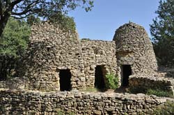 The heart of the Capitelles of Blauzac is an area called La Librotte, and the heart of La Librotte is this trio of dry-stone cabanes. The tree units are tucked tightly together, and share a common little "courtyard". But each of the tree is a separate unit, with no internal passages between them.
[Map coordinates 43.979744,4.380666]
The heart of the Capitelles of Blauzac is an area called La Librotte, and the heart of La Librotte is this trio of dry-stone cabanes. The tree units are tucked tightly together, and share a common little "courtyard". But each of the tree is a separate unit, with no internal passages between them.
[Map coordinates 43.979744,4.380666]
This area of La Librotte has large, walled enclosures, and many of the walls are very long and very thick. Wander through here, we can't help but wonder about the hundreds, or thousands, of man-hours of labor required to build it all.
In our Photo-08 you can see a part of a wall that's thick enough to include a borie directly in the wall.
 This is a view of just a corner of one of the huge enclosures at La Librotte. With, of course, another nice capitelle sitting in the very corner of the enclosure. The next image [Photo-10] is a closer view of this capitelle.
[Map coordinates 43.98026, 4.38105]
This is a view of just a corner of one of the huge enclosures at La Librotte. With, of course, another nice capitelle sitting in the very corner of the enclosure. The next image [Photo-10] is a closer view of this capitelle.
[Map coordinates 43.98026, 4.38105]
Gate-Side Capitelle
 Leaving the special place of capitelles and stone walls beneath the trees, the circuit takes us down a country road to the corner of the Mas de la Librotte, a lovely and very large old stone farmhouse. Beside the gate into the Mas, this capitelle is built into the wall just beside the gate.
[Map coordinates 43.982903,4.381244]
Leaving the special place of capitelles and stone walls beneath the trees, the circuit takes us down a country road to the corner of the Mas de la Librotte, a lovely and very large old stone farmhouse. Beside the gate into the Mas, this capitelle is built into the wall just beside the gate.
[Map coordinates 43.982903,4.381244]
Turning right (southeast) at the Mas de la Librotte, the route takes us back into the woods, then turns south-southwest to head back towards Blauzac. There are a few more capitelles along the way, including this nice one we saw sitting back among the trees [Photo-12]. The capitelle was tall, but the entrance was extremely low.
Books
An excellent book (in French) about the Provence bories, with photos, maps and architectural drawings is:
- Bories
- Parc Natural Régional du Luberon
- Edisud (publisher)
- ISBN 2-85744-720-5
- Parc Natural Régional du Luberon
 After 25 years online, I've decided to remove all Ads from my one-man web Provence Beyond. If the content is enjoyable or useful to you, I would really appreciate your support.