

Adrets Dolmen

Gallery of 18 photos for Adrets Dolmen

The Adrets Dolmens are three separate dolmen sites located in the hills 2.5 km north of Brignoles and 2 km southwest of Le Val.
The northeast dolmen is capped, and easily accessible by forestry roads and wide trails. The southwest dolmen and southeast dolmen are on nearby hilltops without obvious access and require cross-country bush walking to access.
Latitude: 43.427222 N; Longitude: 6.059722 E.
Parking
Driving north from Brignoles. One km after passing beneath the autoroute the road makes a tight switchback to the right and back to the left (west), then bends right towards Le Val. At the final righthand bend, pull off on the left side at a dirt road with a couple of strange big statue-like cement structures.
Driving south from Le Val. From the road junction at the south end of the village, drive south 500 m. Where the road crosses a small bridge and bends left, there's a dirt road at the right, with the strange cement structures.
Park along the beginning part of that dirt road. The hike in will begin along this road.
Northeast Dolmen
 GPS: 43°25'38"N, 06°03'35"E
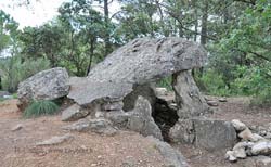
Hike in from the beginning of the dirt road, towards the west, using the IGN map. In 5 or 6 minutes, a wide trail branches off to the left (southwest). In another 6 or 7 minutes, immediately past a dirt track into the trees at the right, the path splits in a Y [photo]. The righthand path goes west, then curves south, up to the top of the hill and joins the wide swath of a buried gas pipeline. The northeast dolmen is there, in the trees on the far side of the pipeline [photo].
This is the only one of the Audrets Dolmens to have a cap stone. The cap is angled, as if one supporting side had fallen away, but by observing the shape of the end stones, it seems it was designed this way.
We were here a few years ago (pre GPS) and nothing much has changed (a few years is nothing in the life of a dolmen). We think there was no pipeline swath through here then, and the trails weren't as obvious then.
Southwest Dolmen
 GPS: 43°25'29"N, 06°03'17"E
Starting from the capped northeast dolmen, we hiked west along the gas pipeline route about 5 minutes. A trail goes left (south) through the bushes. Another few minutes and the trail makes a hard righthand turn, then crosses down over a low stone wall. Just past that, we went left off the trail (south-southwest), cross-country, aiming for the top of the hill with trees mainly at the top.
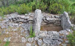
We ended up on a small path on the southeast side of the hill before the final climb to the top [photo].
This dolmen (no cap stone) is nicely shaped and out in the open light.
The IGN appears to show two dolmens at this site. The nice one we found is at the top of the hill, and the northern edge of the hilltop. We hiked all around the hilltop, and down to the south without finding another. We did find a small, round stone structure, like a narrow topless borie, but no other dolmen.
Southeast Dolmen
 GPS: 43°25'29"N, 06°03'35"E (our observation)
GPS: 43°25'29"N, 06°03'38"E (small site on hillside?)
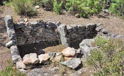
Looking east from the hilltop with the southwest dolmen you can see the forested hill where the southeast dolmen dwells [photo]. Getting there was not easy. Cross-country through thick underbrush for most of the way, with no trails at all. Arriving finally at the hilltop site, we also found no other trails leading in or out.
This southeast dolmen is in an open clearing, nicely presenting the site for observation [photo].
The GPS coordinates we recorded for the dolmen seemed too far from the "official" coordinates we found online, so we went exploring. Down onto the hillside 30-40 m to the east, in thick underbrush, we found what could have been another small dolmen. This would have been in the "correct" location, but to our untrained eyes it was ambiguous at best.
Return Trip
If you strike south from the southeast dolmen (or from the southwest dolmen), there may be small trails back to civilization. But for visiting all three, we had parked on the northeast side and needed to head back in that direction. We went northeast down off the hilltop, through very thick undergrowth and fairly steep. With determination, the sun for guidance and a bit of luck we came out on the forestry road southeast of the first (capped) dolmen, and had only to retrace our steps along the forestry roads to the car.
Hiking
• GPS: 43.42513, 6.063664
Maps
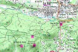
IGN (1/25,000) #3444 OT "Brignoles Le Luc"
 Beyond has labeled these three dolmen-sites as northeast dolmen, southwest dolmen and southeast dolmen.
 After 25 years online, I've decided to remove all Ads from my one-man web Provence Beyond. If the content is enjoyable or useful to you, I would really appreciate your support.