

Nyons
• Drôme (26110) • Population: 6,353
Gallery of 19 photos for Nyons

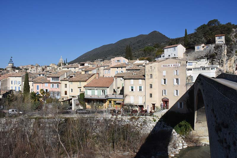
Nyons is a small medieval town located in a lovely river valley at the edge of the Barronies area of the Drôme departement. The town center has busy squares with shops, cafés and restaurants, and a couple of ancient "old-town" areas with narrow streets, long arched passages, and some interesting old sites to visit.
Nyons is somewhat reminiscent of Sisteron, with the river flowing down past the town through a narrow gap of a high rocky ridge opposite rock cliffs. Instead of an imposing citadel, though, Nyons has a small chapel tucked in the trees on top of the high rocky ridge.
There was, once, a citadel in Nyons. It was located across the river from the town, on a hill just south of the arched Pont Roman. Built in 1585, it's now long gone. A private house at the approximate location is still called La Citadelle on IGN hiking maps.
Pont Roman
 Not Roman, but Romanesque, this single-arched stone bridge was built in the 14th century, sort of. Begun in 1340, construction took about 70 years, and wasn't open until 1409, when it was inaugurated by the Bishop of Vaison.
In spite of periodic flooding of the Eygues, the 18-m high arched bridge has been in constant use for the past 600 years, and is still open to automobile and pedestrian traffic.
Feudal Castle
 A castle was built in the 16th century and the south end of the Rocher du Maupas, a narrow north-south ridge that now continues north from the center of the current town center. Some of the original castle walls are still visible along the mostly-covered Rue des Grands Forts, but it's difficult to identify them if you don't know what you're looking for.
The castle entrance is through a pair of joined, round towers (our photo) that is only visible when you're standing directly in front of it, located in the very narrow Rue des Grands Forts.
Known as the Chateau Féodal or the Chateau Vieux, it was converted into a presbytery in 1731, then sold at public auction in 1779. It's now privately owned and nicely restored.
Tour Randonne
 The original Radonne Tower was built 1280 in the ancient center of Nyons, the Quartier des Forts on the rocky ridge just north of the current town center. The defensive tower was built by the current lord of Nyons, Randonne de Montauban, who was the Baron of Montauban.
In 1862 the curé of Nyons acquired the tower and converted it into a chapel. He then extended the top with a three-level pyramid of thin arcades topped by a statue of the Virgin. A bit gaudy, but today its the most uniquely identifiable landmark in the town.
Campanile Bell Tower
 A lovely wrought-iron Campanile tops the 14th-century bell tower at the Porte de la Pomme. The tower originally marked one of the defensive entries into the Medieval walled town. In the 18th century, a storm wrecked the earlier pyramidal top, which was replaced by the "newer" campanile. Inside the campanile is the original 1352 bell.
Nyons Olives
 Nyons is renowned for its olives and olive oil. The black olives of Nyons and the olive oil of Nyons are both classed AOC (Appellation d'Origine Contrôlée), just as for quality wines.
History of Nyons
Name
First record, 972 Niomes: cited in an act donating the Saint-Vincent and Saint-Ferréol churches to the Abbey Saint-Césaire d'Arles.
Gallo-Roman: In Gallo-Roman times, Nyons was attached to the Roman town of Vaison (Vasio Vocontiorum) 17 km to the south, now known as Vaison-la-Romaine.
Hiking

• GPS: 44.360416, 5.139692
Déves Trail
A very nice short (2-hour) hike goes up the ridge on the northeast side of town to a small stone chapel on the edge of a cliff with a fabulous view east up the valley over the Baronnies. The up-and-back trail begins on the Rue de Devés (gps 44.361492, 5.142807), where there is an panel with information (in French and English) about the trail and the things to see along the way. Along the trail itself there are other info-panels about the sites, history and nature.
Déves Loop Hike
For a slightly more adventurist hike, you can hike up through the oldest part of town and then follow a trail that traverses up across the west side of the hill to meet the ridge trail a little below the chapel. You can go left at the trail junction, up to the chapel, and after a visit there, follow the trail back down the ridge all the way tot eh Rue de Devés.
For the start of this loop, go up through the northern end of the old town, Prom. des Anglais or Rue Pierre Toesca, to Meyne. At the junction of rue Meyne and Le Devès (gps 44.367286, 5.139435), continue up Le Devès and follow the yellow trail marks and signs.
GR9 (Grande Randonnée)
The local Déves Trail is just a short section of the GR9 trail that passes through Nyons. Northward, the GR9 goes up the ridge and continues through the forested hills to Dieulefit, about 30 hiking km. There are a lot of hills and valleys along the way, the the highest point at 1340m.
Southward, the GR9 crosses the Medieval arched bridge and goes southeast to Buis-les-Baronnies, about 25 km. Continuing southward, the GR9 goes another 25 km to the south where it joins the GR04 hiking trail at the famous Mont Ventoux.
Promenade de la Digue
A nice walking path follows along the right bank of the Eygues river, from the arched Pont Roman southwest to the gué de la Sauve (the ford of the Sauve), a leisurely half-hour (2 km) walk.