

Boulbon
• Bouches-du-Rhône (13150) • Population: 1,510 • Altitude: 51 m

Gallery of 25 photos for Boulbon

Boulbon is a very interesting little village on the east side of the Rhône river between Tarascon and Avignon. Below the perched ruins of a chateau-fortress, narrow village streets have ancient doorways, 12th-century statues, old sundials, and remnants of the Medieval walls that once circled the base of the fortress cliffs.
There are two separate "centers" of Boulbon village. At the north part of the village, the town hall, post office, grocery store form a small place at the junction of the streets. From here, the 13th-century walled portail, Porte Lorial, gives entrance to the north end of the Grand Rue that runs the full length of the old village.
The wide, shady Place Gilles Leontin extends to the west from the lower (southern) part of Boulbon village. This serves as the main parking area of the village, and has the feeling of a Camargue town, with wide walkway and long petanque pitches beneath the lines of plane trees.
Access. Boulbon can be accessed on the D35 highway, either from Tarascon in the south or Barbentan in the north (near Avignon). Arriving from the east, past Gravenson, is the most interesting. You follow the narrow and winding D81 road over the Montagnette pine-forested hills, passing the front gate of the picturesque Saint Michel de Frigolet Abbey.
Audio Entertainment. On a Saturday visit we found (and heard) the village audio entertainment being provided by a hand-cranked player ORGAN opposite the butcher on Grand Rue. Talking with the player-organ grinder, he picked up on our non-French accents and brought out the music for Marche Alford, Hello, Le soleil Brille, popularised by the American troops who had liberated the area – when he was fifteen years old.
Shops
 Boulbon village has the basic village shops, including an excellent bakery at the north end near the post office, and an award-winning butchers shop on the narrow Grand Rue in the heart of the old village.
The village terrace café, Café du Commerce, is located on the long Place Gilles Leontin, beside the L'Astrado, a tabac-magazine-paper shop.
Boulbon Castle
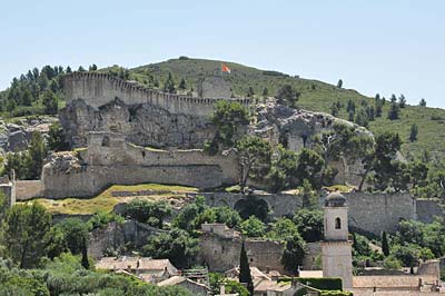 The 11th-century Feudal fortress of Boulbon sits on a rocky pinnacle immediately above the village. It has a very Medieval castle look to it, although it's now mostly ruins, privately owned and non-visitable.
You can hike from the village up to the iron gates and peer in at the courtyard, but the best views are from the Moulin Bonnet, just a few minutes up the hill, or from the other windmill tower above Chapelle Saint Marcellin and the cemetery.
Windmills
 The Moulin Bonnet windmill (moulin à vent) stands on a hilltop just north of Boulbon village. (GPS 43.865113, 4.695098) It's in good condition, complete with the four sail blades. The most direct walking access to the windmill is from a small, shady parking area at the north end of the village, at the end of Rue Font de Bernard.
The trail follows a narrow stream bed (usually dry) northeast from the parking area, then loops left up the hillside and makes a final approach to the windmill from the north. There's a striking view from the windmill hilltop, in a wide panorama across the south, past the Boulbon fortress ruins and village, with Tarascon castle in the distance.
The stone tower of a second windmill, without top or sails, is on the end of a hill 300 m west of Moulin Bonnet (GPS 43.865586, 4.691617), overlooking the cemetery and the old Chapelle St-Marcelin. You can go inside this tower, and even climb the old steps, but not high enough to see over the top.
Chapelle Saint Marcellin
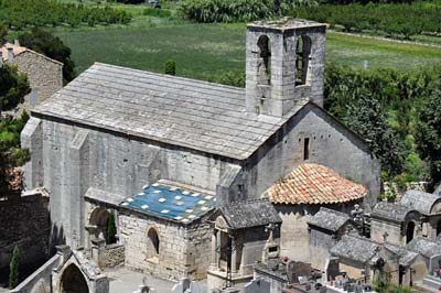 The 12th-century Saint Marcellin is located at the cemetery, at the north edge of Boulbon village. The Provencal Romanesque style chapel is built on the site of an 11th-century church, and some vestiges of the original can be seen in the western facade. Saint Marcellin was used as a parish church until the 17th century (1628).
Chapelle Saint Julien de Boulbon
Saint Julien de Boulbon is a 12th-century Romanesque chapel located 3 km north of the village, on the south side of the D81 road towards the St-Michel de Frigolet Abbey. The chapel is built entirely of fitted stone, with a slate roof, and a lovely pentagonal apse.
Sundials
We found two old sundials in Boulbon. Neither have colored facades, but both are authentically ancient looking. The larger of the two is just inside the defensive portal at the north end of Grand Rue. The smaller sundial is hight on a very narrow building where a small street joins Grand Rue about half way along its length. Both are south facing – handy, considering their location in such a narrow street.
Floods
 We've often seen flood markers in villages: plaques or engravings on walls indicating the height of severe floods in past years and centuries. In Boulbon, a tall, narrow obelisque at the west end of Place Gilles Leontin, is engraved with the village's flood history. The obelisque is at the entrance gate to the community center and petanque-sports area.
The highest mark on the stone is at about 2m30 (7 feet). With water that deep, this would be a very wet town indeed, with just a cliff-top fortress above a sea of roofs. Most of the dates engraved here were in the 19th century; the oldest flood date was 1840 and the most recent was 2003.
History of Boulbon
Name
First record, 1003 Castrum de Burbone
In 1003 th rights to the Castrum de Burbone were ceded by Aelaïs, the Countess of Avignon to the Bishop of Avignon. The domain (Seigneurie) of the Bourbons began in 1041, converted to the Count André d'Oraison, who's familly retained the castle until 1956.
Hiking
• GPS: 43.862999, 4.693600
There are a number of hiking trails through the hills and narrow, rocky valleys north and east of the village. You can start from the little parking area at the north end of the village (Rue Font Bernard), from the paths up past the St Marcellin Chapel and the cemetery, or from the bottom end of Rue Grande and going up the valley on the east side of the fortress.
Saint Michel de Frigolet Abbey. An hour's hike east of Boulbon (3.5 km) takes you to the very interesting Abbey de Saint Michel de Frigolet. You should allow a couple of hours, at least, to visit the Abbey before starting back on the same trail.
Transportation Boulbon
Department 13, Bouches-du-Rhône Buses
- See Beyond's Bouches-du-Rhone (13) Bus Schedules for downloading Bouches-du-Rhone bus-lines map and bus-line schedules [pdf for each line] (link for PDF files).