

Le Lauzet-Ubaye
• Alpes-de-Haute-Provence (04340) • Population: 212 • Altitude: 900 m
Gallery of 5 photos for Le Lauzet-Ubaye

Le Lauzet-Ubaye is a small mountain village built on the gorge of the Ubaye river, a few kilometers before it empties into the Lac de Serre-Ponçon. The village is built on a sort of narrow rock island, with a deep valley in front and the deeper gorge of the Ubaye river behind. • Market day Thur.
The narrow streets between the houses have a medieval feel, but the roofs, balconies and wide ramps leading to the upper-floor barns is Alpine style [photo-3, photo-4]. There's a big stone church in the center of the village, with a nice fountain in the center square [photo-5]. Village commerce consists of a few shops and café-restaurants.
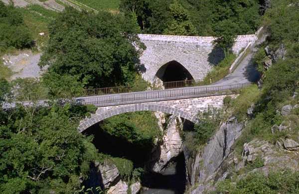
A tiny road goes down to the "new" bridge over the gorge, just beside the arched stone Roman bridge [photo-1, photo-2]. Another path, probably the old Roman road, loops around the rocks to bring you back to the village.
History of Le Lauzet-Ubaye
The commune of Le Lauzet-Ubaye combined the villages of Ubaye and Lauzet, but Ubaye was flooded in 1960 when the Serre-Ponçon dam was completed and the lake was created.
Gallo-Roman: A Roman presence here is attested to by the beautiful single-arch Roman bridge across a deep gorge of the Ubay river [photo-2].
Medieval: The Counts of Provence ruled this area until the 14th century, then the Dukes of Savoy until 1713.
Dates
Market day: Thur.
Apr (1st Thur) - Foire
May (2nd Mon) - Foire
Hiking
• GPS: 44.428286, 6.43507
Maps
Didier Richard (1/50,000) #1 "Alpes de Provence"
There are loop hikes in the mountains on both sides of the Ubaye river, with a connecting trail passing through the village and across the gorge on the "new" bridge.
The mountains to the south are the most forested, with peaks at about 1500-1800 m. The northern slopes are forested up to around 1700-1800 m, but the peaks go up to 2500-2800 m.
Transportation Le Lauzet-Ubaye
Bus Gap - Barcelonnette
- The Gap - Barcelonnette bus route is: Gap, La Luye, L'Archidiacre, Remollon, Rochebrune, Espinasses-Serre-Ponçon, La Bréole, Les Terrasses, Le Lautharet, St Vincent-les-Forts, Le Villaret, Le Lauzet-Ubaye, Champanastais, Le Martinet, L'Arché, La Fresquière, Rioclar, Les Thuiles, La Lauze, Barcelonnette.
- Trip time is 2h30.
- The route and schedule is available on the SCAL-Autocars website (link just below). - Web: www.scal-amv-voyages.com/ligne.htm
Department 04, Alpes-de-Haute Provence Buses
- See Beyond's Alpes-de-Haute Provence (04) Bus Schedules for downloading Alpes-de-Haute Provence bus-lines map and bus-line schedules [pdf for each line] (link for PDF files).